
Trailbreaker Resources LTD
Sheldon

Introduction
The Sheldon property is located within the fertile and highly prospective Tombstone Gold Belt of the Selwyn Basin of the Yukon Territory, 110 km northeast of the town of Ross River. The Tombstone Belt is host to gold (Au)-bearing prospects and deposits including: Snowline Gold’s Valley discovery (e.g. 410.0 m @ 1.89 g/t Au); Kinross Gold’s Fort Knox mine (10 million ounces of gold, including past production) and Victoria Gold’s Eagle mine (4.3 million ounces of gold).
The property is accessible via the North Canol Road to within 800 m of the property boundary. The Sheldon property covers 919 ha centered on a mid-Cretaceous granitic intrusion hosting “Reduced Intrusion Related Gold System” (RIRGS) style of mineralization. The claim package is 100%-owned by Trailbreaker Resources with no underlying royalties or payments.
Gold at the Sheldon property was first recognized in 1944 by the Geological Survey of Canada (GSC). Subsequent regional stream sediment sampling in 1990 conducted by the GSC highlighted anomalous arsenic (As) and antimony (Sb) in drainages from the property. With the discovery of gold at Dublin Gulch and the focus on intrusion-related gold deposits in the early 1990s, the project was staked for the first time in 1991. Between 1991-1993, three short surface campaigns were conducted at Sheldon, recognizing gold associated with granite-hosted quartz and arsenopyrite veining. The property stayed dormant until 2012, when another surface program was conducted. No work has been conducted at Sheldon since.
Previous work campaigns recognized gold associated with quartz and arsenopyrite veining hosted in a polyphase mid‑Cretaceous biotitic granitic to granodioritic stock and surrounding hornfelsed sedimentary rocks. Sampling from this work returned assay values up to 6.17 g/t Au from this style of mineralization.
The property displays many classic characteristics of RIRGS deposits, including the timing of mineralization relative to other RIRGS in the Yukon, the geological setting, mineralization style, alteration, and geophysical characteristics.
Due to the relatively small amount of historic work on the property, the property remains underexplored. Gaps between anomalous gold in geochemical data remain large enough to have deposit scale anomalies between. As well, strong geophysical targets remain untested.
Trailbreaker’s team believes there is strong potential for a bulk-tonnage RIRGS gold deposit to occur on the Sheldon property.
Location & Infrastructure
The property is located approximately 110 km northeast of the town of Ross River along the North Canol Road. The property has excellent infrastructure with road access to within 800 m of the property boundary.
The nearby communities of Ross River and Whitehorse provide excellent exploration resources and trained personnel.
History
Gold-bearing quartz veins were first recognized at Sheldon by the Geological Survey of Canada (GSC) in 1944. In 1990, a regional stream sediment survey conducted by the GSC highlighted multiple drainages with anomalous arsenic and antimony.
The work conducted by the GSC, along with the then-recent discovery at Dublin Gulch (now Victoria Gold’s Eagle Mine) in Yukon, resulted in the initial staking of the property in 1991. Between 1991-1993, surface rock and soil geochemical sampling, as well as geological mapping, were completed, targeting Fort Knox style mineralization. Rock chip samples from this work returned assays as high as 6.17 g/t Au, from quartz veining in the granitic Sheldon Stock.
The claims were restaked in 2011, followed by a short prospecting and sampling program conducted in 2012. Rock samples from this program graded up to 2.08 g/t Au.
Since 2012, no work has been completed on the property.
Geology & Mineralization
The Sheldon property is centered on the mid-Cretaceous Sheldon stock, a member of the Tombstone Gold Belt intrusive suite emplaced within the Selwyn Basin of Yukon. The Sheldon stock is described as a polyphase biotite granitic to granodioritic intrusion, emplaced during a regional extensional event coincident with emplacement of the Tombstone intrusive suite. Gold mineralization is associated with quartz and arsenopyrite veining within the Sheldon Stock, as well as in hornfelsed sedimentary rocks surrounding the stock.
The Sheldon property displays many classic features of RIRGS deposits, including but not limited to:
- Sheeted quartz veins hosted in a mid-Cretaceous granite;
- Intrusive rocks with biotite>hornblende, indicating volatile content of the intrusion;
- Restricted sized of intrusive stock is favourable for hosting RIRGS;
- Strong gold-arsenic-bismuth-tellurium-tungsten (Au-As-Bi-Te-W) geochemical association;
- Typical geophysical characteristics (resistivity high and magnetic high around stock) of a felsic intrusion surrounded by a hornfelsed aureole in sedimentary rocks
The Sheldon property is underexplored and has undergone only short surface sampling campaigns between the early 1990s and 2012.
A regional-scale Z-Axis Tipper Electromagnetic (ZTEM) survey was flown over a significant portion of the Selwyn Basin in 2008. This data was reprocessed by Condor Consulting in 2013 and made publicly available by the Yukon Geological Survey. The data from this survey shows magnetic and conductivity characteristics across the Sheldon property that are common in RIRGS deposits. These features include a high resistivity signature associated with the felsic intrusive rocks and magnetic high features surrounding the intrusions, associated with pyrrhotite‑bearing hornfelsed sedimentary rocks. Of particular interest are two magnetic ‘pimples’ within the claim boundaries that may reflect strongly hornfelsed rocks above a blind intrusion. As the highest grades of RIRGS mineralization commonly occur in upper portions of fertile intrusions, the potentially intact carapace in the northwest and southeast property areas highlight attractive exploration targets.
Most geochemical sampling and mapping to date has been focused on the southern extent of the Sheldon Stock, where gold mineralization was first encountered. Although less geochemical coverage occurred along the northern flank of the stock, the more limited work revealed consistently elevated gold values from rock and soil sampling. Additionally, this area has the best correlation between gold (Au) and tellurium (Te), a robust pathfinder element for Au in RIRGSs. The spacing between sampling in this area is such that a significant deposit could occur between sample locations, based on the approximate footprint of other RIRGS deposits, including Snowline Gold’s Valley prospect.
Presentation
Maps
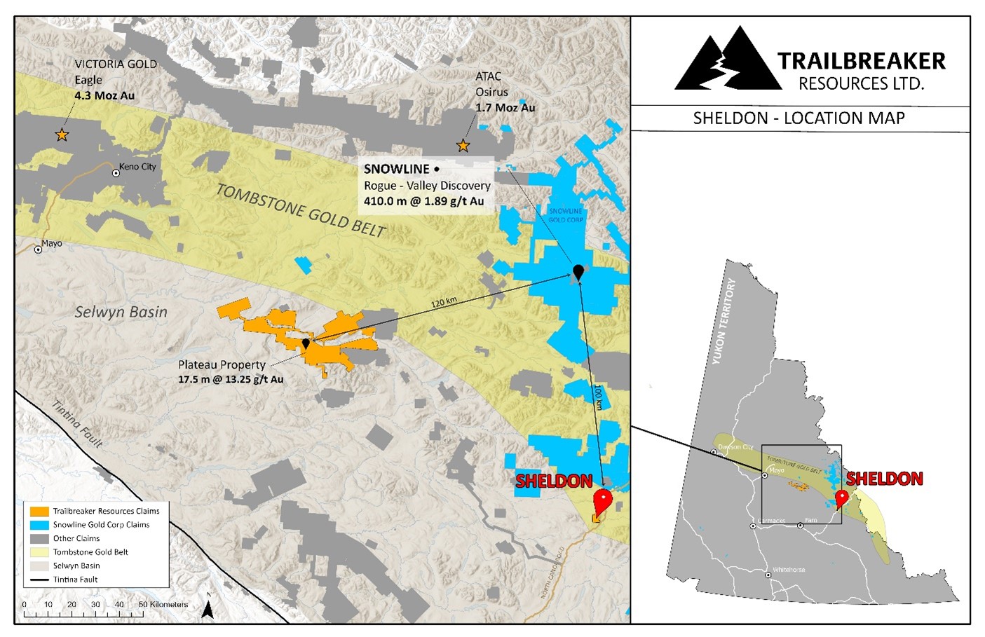
Figure 1: Location of the Sheldon property within the Tombstone Gold Belt and the Selwyn Basin.
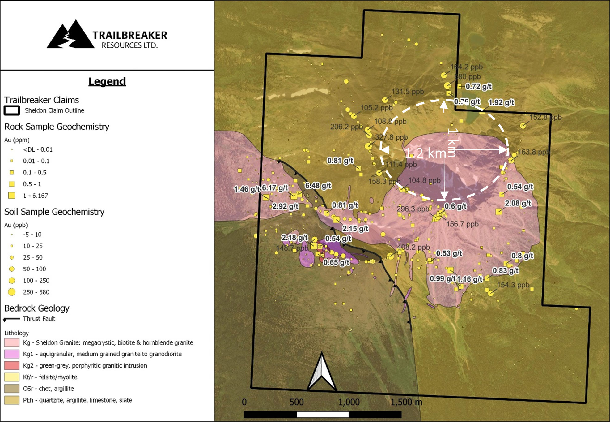
Figure 2: Gold in soil and rock samples overlain on mapped geology of the Sheldon property. Gold shows a strong correlation with the granitic stock and locally the hornfelsed sedimentary rocks. White dashed ellipsoid indicates 1 km x 1.2 km area with limited sampling and elevated Au-Te values in surrounding samples.
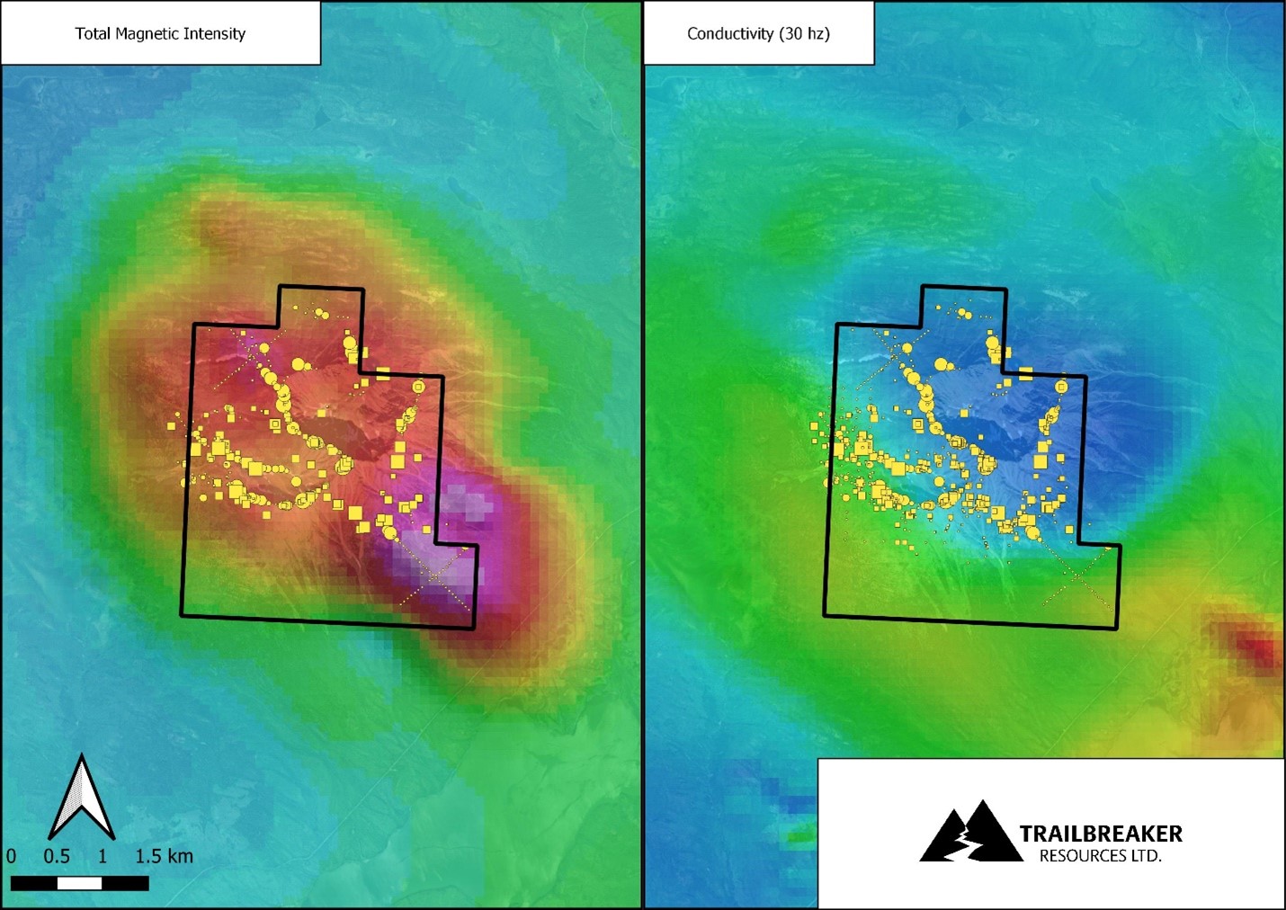
Figure 3: Low conductivity (high resistivity) features indicate the presence of an intrusive center at the Sheldon property, as confirmed from regional and local mapping. Strong magnetic highs are associated with hornfelsed sedimentary rocks in the aureole of the intrusion.
Address
Trailbreaker Resources Ltd.
650 W Georgia St # 2110
Vancouver, British Columbia
Canada, V6B 4N9