TRAILBREAKER Resources LTD
Wheaton Gold

Introduction
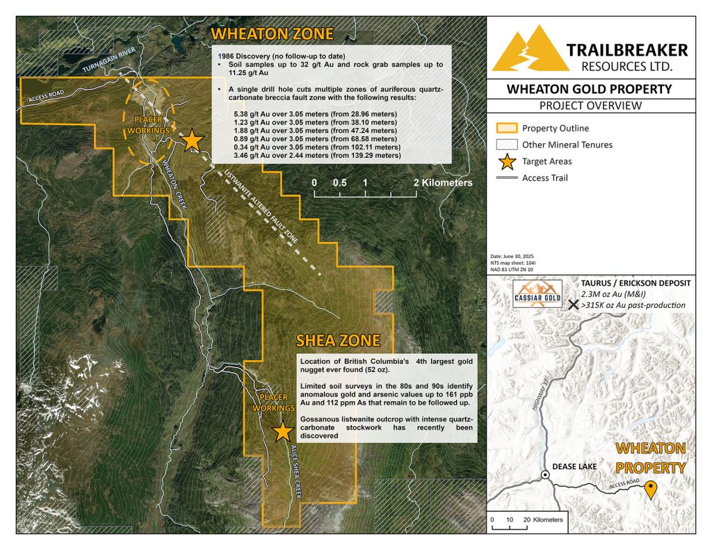
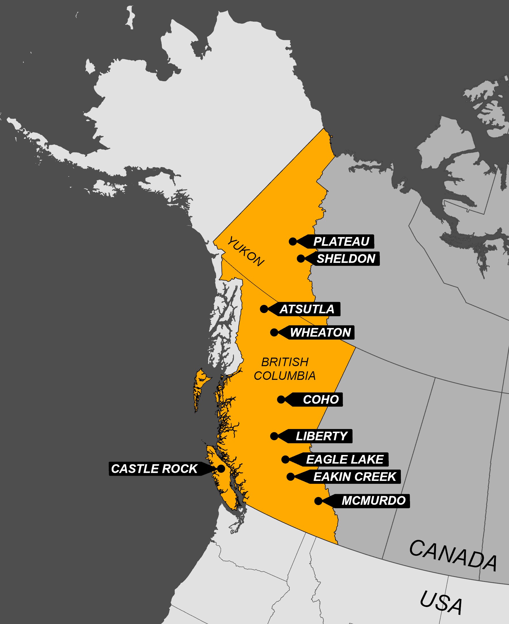
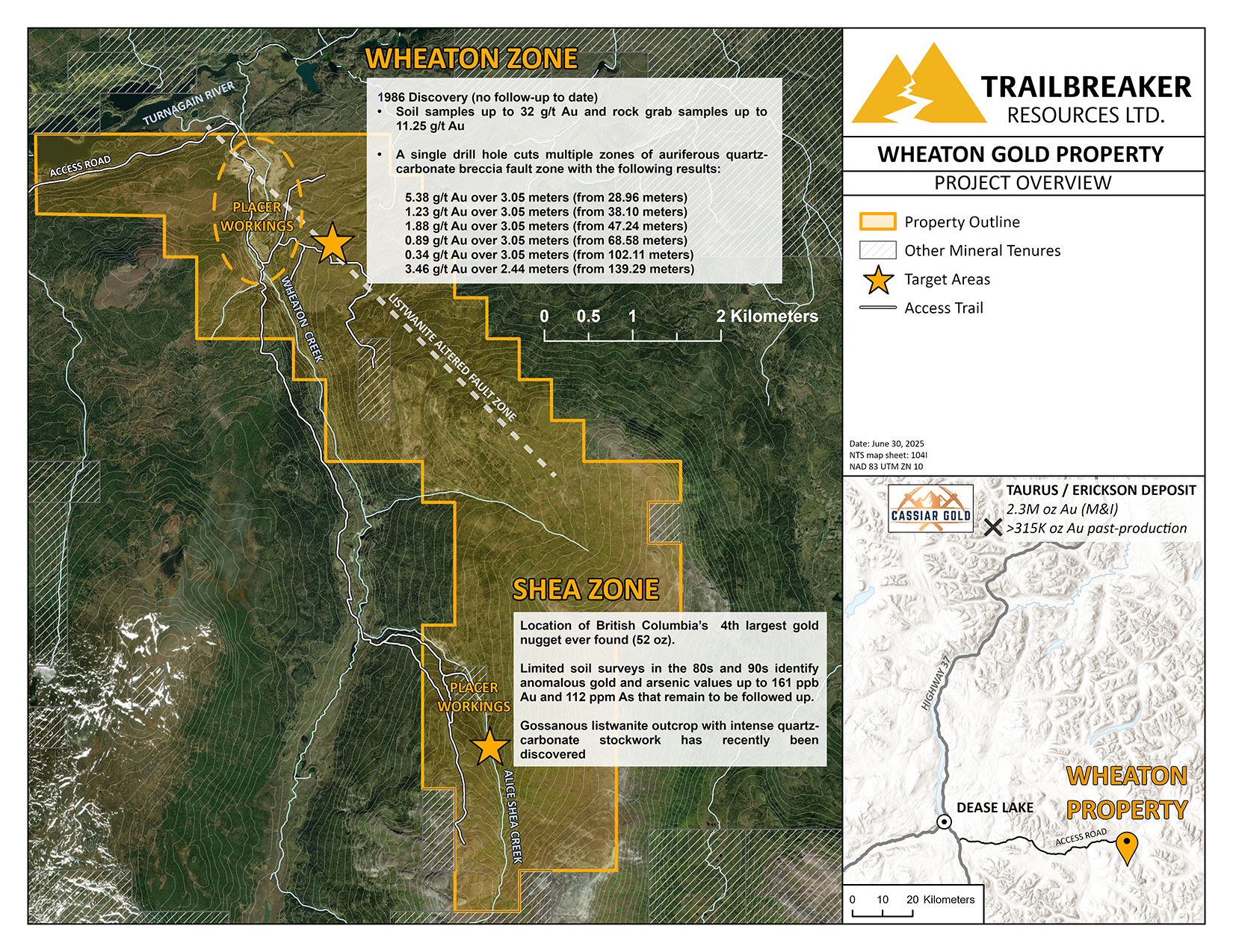
The Wheaton Gold property is grassroots, high-grade orogenic gold prospect in northwest British Columbia, 60 km kilometers east of the Village of Dease Lake, BC. The 2,223-hectare claim group (~2 km x ~9 km) covers the headwaters of the placer gold-bearing Wheaton and Alice Shea Creeks, which are famous as the source of BC’s coarsest gold nuggets, including the fourth largest nugget ever found in BC, weighing in at 52 oz. Wheaton represents one of BC’s most underexplored placer districts with very limited hardrock exploration work done to date.
Location, Access & Infrastructure
The Wheaton Gold property is located approximately 60 kilometers east-southeast of the Village of Dease Lake in northwestern British Columbia and can be accessed by all-terrain vehicles utilizing the Boulder Mine Road. The property can also be accessed by float plane chartered from Dease Lake to Boulder City Lake. Historic placer mining trails provide good vehicle access to much of the property.
Giga Metals Corporation has proposed a major road and transmission line to its advance-stage Turnagain nickel-cobalt deposit, located 10 km to the east. This would bisect the northern end of the Wheaton Gold property, further bolstering the potential economic viability of the area.
History and Exploration Highlights
Placer Mining History
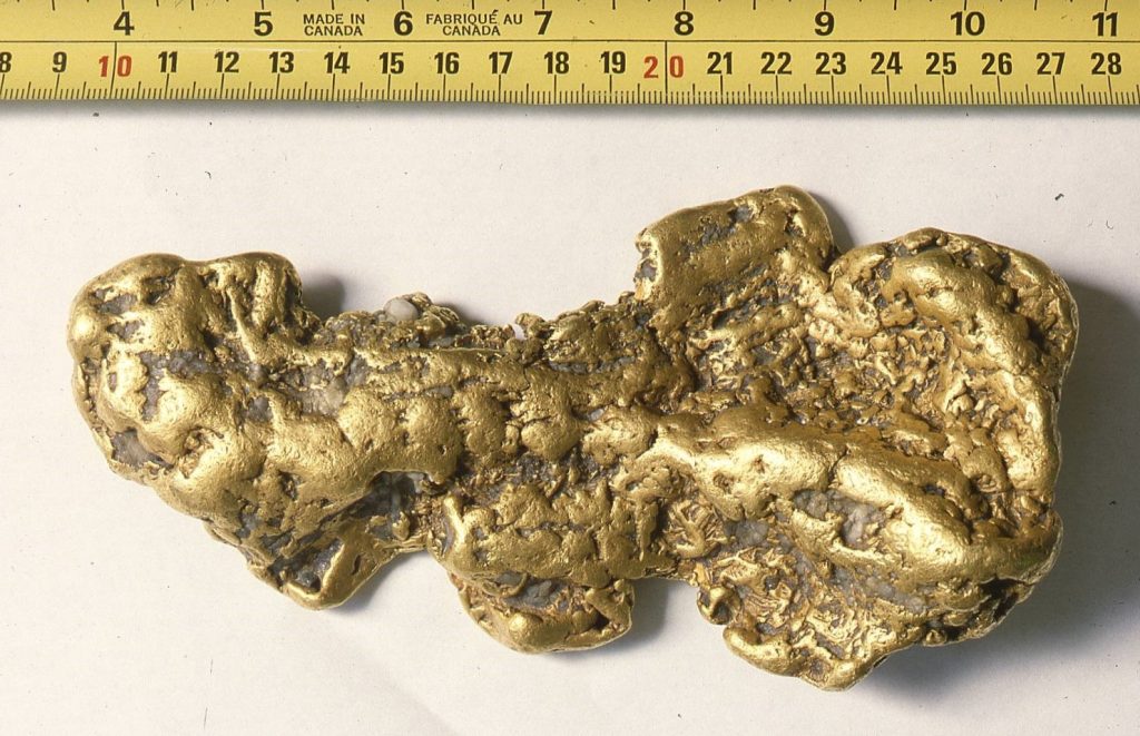
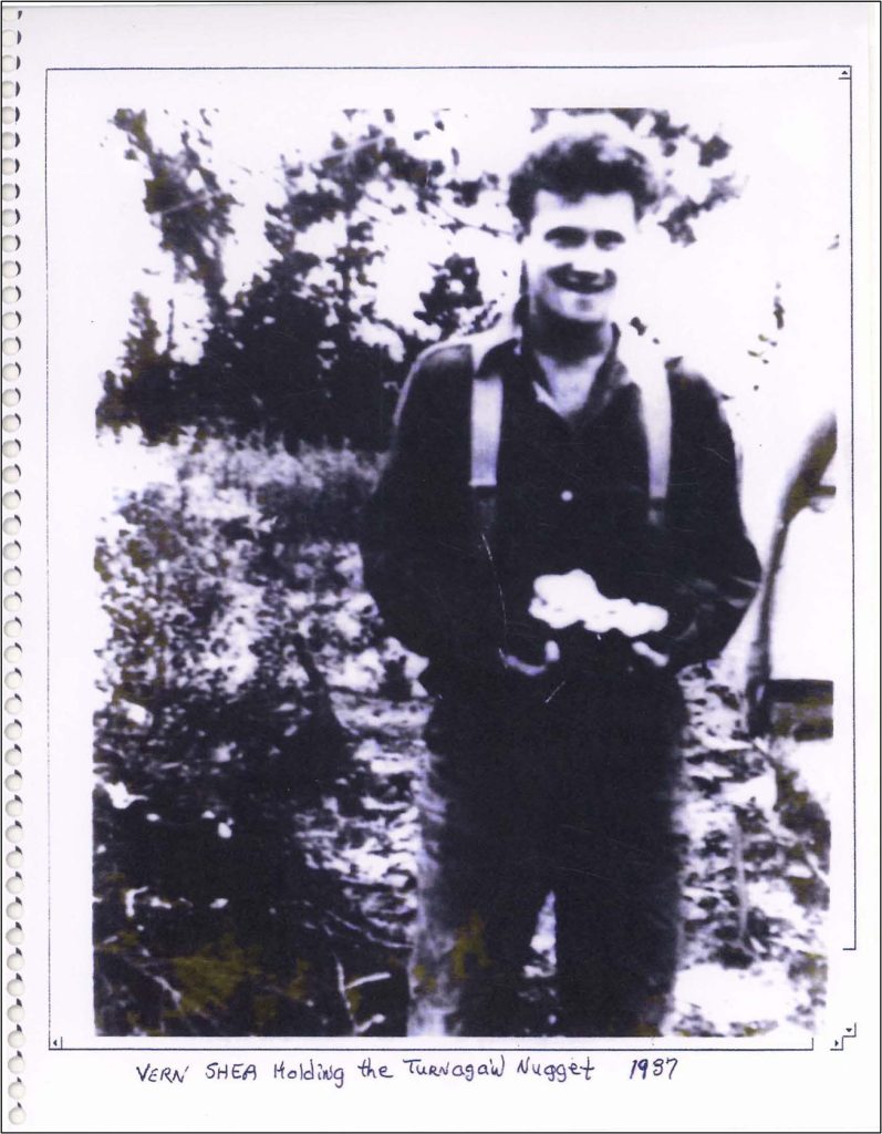
Placer gold was first discovered at the mouth of Wheaton Creek (formerly Boulder Creek) in 1932 and shortly afterwards on Alice Shea Creek, a small tributary of Wheaton Creek. The Wheaton-Shea placer camp marked the last major placer gold discovery in BC, with a total of 7,756 oz of placer gold mined from Wheaton Creek between 1932 and 1945, and a total of 331 oz Au mined from Alice Shea between 1936 and 1940. Alice Shea Creek produced the coarsest placer gold in the drainage, with one nugget weighing over 52 troy oz (the Turnagain nugget) and numerous nuggets weighing from 1 to 16 oz. Modern-day placer mining continues to this day at the mouth of Wheaton Creek, with over 20,000 oz of placer gold estimated to be recovered to date.
Wheaton Zone
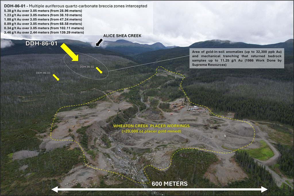
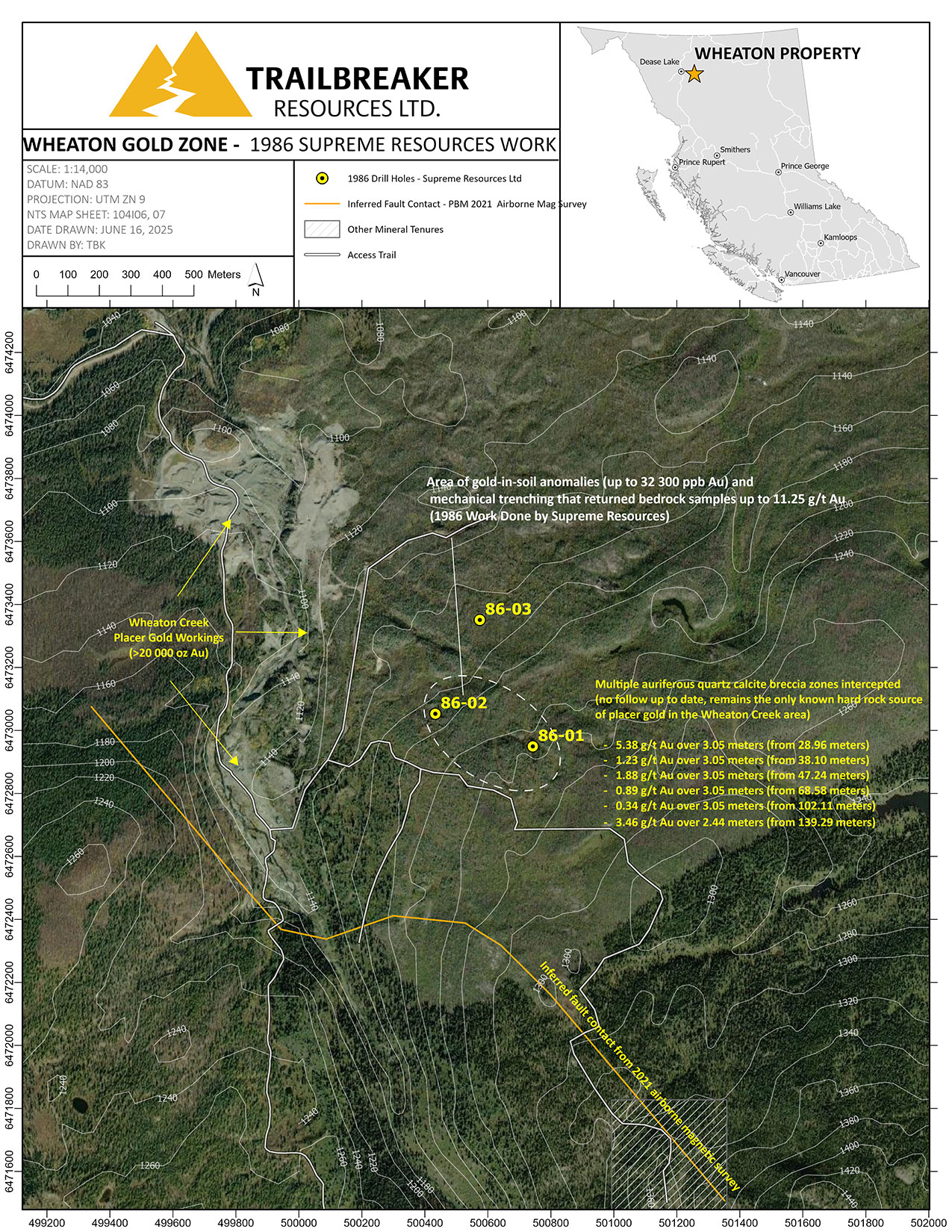
The northern portion of the property, covering the present-day placer operations near the mouth of Wheaton Creek, has seen the least amount of hardrock exploration within the property, having undergone only one documented significant exploration program, completed in 1986 by Supreme Resources (Supreme). That year, Supreme conducted a soil geochemical survey followed by a mechanical trenching program which returned very encouraging results, and identified strongly anomalous gold-in-soil values up to 32,300 ppb Au. Trenching within these soil anomalies returned rock gab samples up to 11.25 g/t Au. During the same year, Supreme tested this zone with 3 shallow diamond drill holes totaling 304.7 meters. However, only limited follow-up work in the last 39 years has been documented.
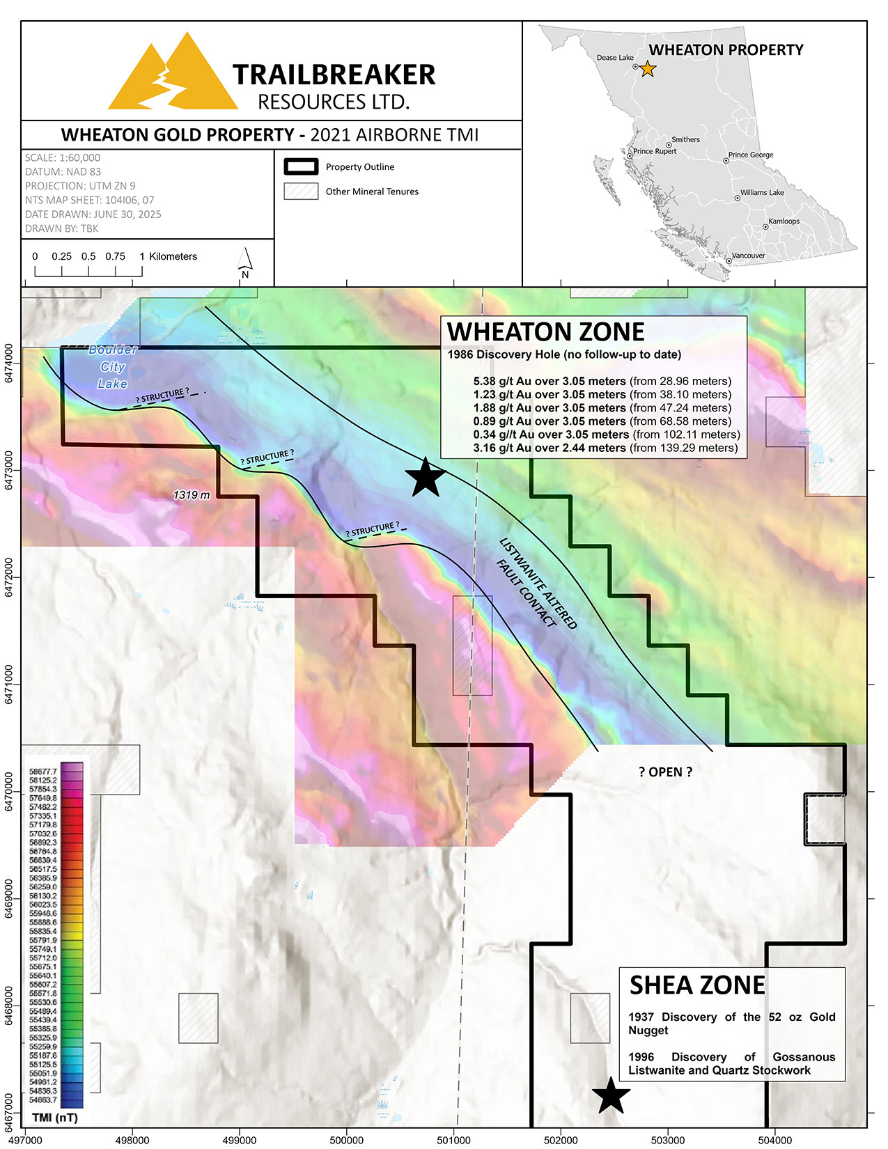
Hole DDH-86-01, the first of the 1986 program, encountered several gold-enriched intervals associated with fault-controlled quartz-carbonate breccia, including:
- 5.38 g/t Au over 3.05 meters (from 28.96 meters)
- 1.23 g/t Au over 3.05 meters (from 38.10 meters)
- 1.88 g/t Au over 3.05 meters (from 47.24 meters)
- 0.89 g/t Au over 3.05 meters (from 68.58 meters)
- 0.34 g/t Au over 3.05 meters (from 102.11 meters)
- 3.46 g/t Au over 2.44 meters (from 139.29 meters)
The other two holes underwent very limited sampling, with only two samples taken from DDH-86-02 and one from DDH-86-03, all returning trace gold values.
This work by Supreme resulted in the first and only discovery of hardrock gold mineralization that could be linked to the source of the rich placer gold deposits along the lower portion of Wheaton Creek.
![]()
Pacific Bay Minerals, a junior mining company, held the ground from 2015 to 2024 but conducted very limited exploration. Much of Pacific Bay’s efforts were focused on mining jade boulders rather than on hardrock gold exploration. Their most significant work included a 2021 property-wide airborne magnetic survey that defined an open-ended NW-SE trending linear magnetic low feature that correlates with the 1986 discovery hole by Supreme. This is interpreted to potentially represent a listwanite-altered fault zone. Listwanite and listwanitic alteration is extensively documented around Alice Shae Creek (expanded upon below).
This survey provided several new exploration targets which have not been tested to date. Several east-west trending offsets occurring near the Wheaton zone may represent potential structures associated with gold mineralization.
![]()
Shea Zone
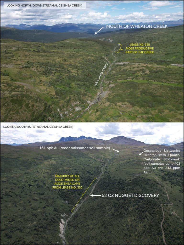
The Shea zone is located along the headwaters of Alice Shea creek, close to the discovery area of the 52 oz Turnagain gold nugget. The nugget was discovered in the upper extent of the drainage, narrowing the search for the hardrock source.
The majority of the exploration work done at the Shea zone was done from 1985 to 1996, with several junior mining companies conducting small-scale exploration surveys. This includes companies such as Powder Ridge Resources, Imperial Metals, Goldbank Ventures, and Loumic Resources.
Loumic Resources’ 1996 exploration program was the most robust, comprising 196 soil samples and 191 meters of mechanized trenching. Reconnaissance soil sampling identified several anomalous gold-arsenic zones (up to 161 ppb Au & 112 ppm As) that have yet to receive follow-up exploration. Furthermore, trenching, targeting gossanous float immediately upslope from the location of the 52 oz gold nugget, revealed a listwanite outcrop containing intense quartz stockwork and disseminated pyrite. Only trace gold values were returned; however, the mineralization and alteration are textbook markers for orogenic gold deposits. This marked the last significant gold exploration program occurring on the Shea zone.
In 2011, First Point Minerals Corp was the last junior mining company to work the property; however, they focused on nickel mineralization rather than gold. Gold analysis for rock grab samples during the 2011 program utilized a 4 g/t detection limit, much higher than fire assay detection limits commonly used.
Deposit Model, Geology, And Mineralization
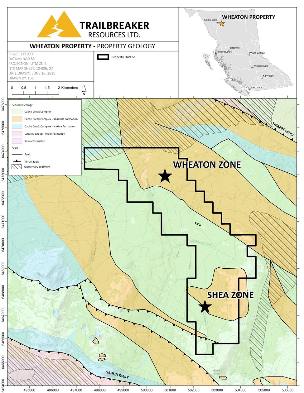
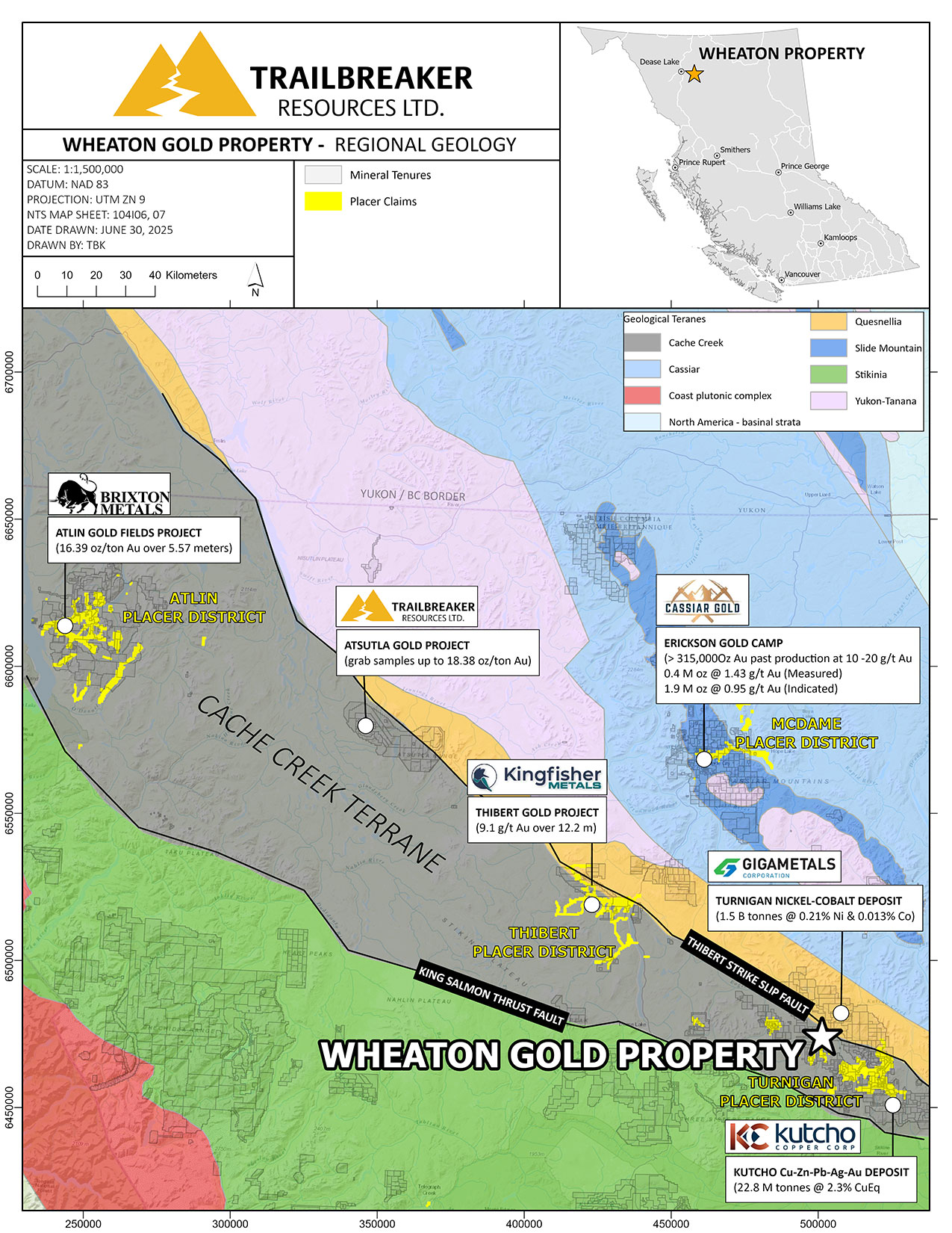
The Wheaton Gold property is underlain by northwest-trending, complexly folded and faulted ultramafic rocks of the oceanic Cache Creek terrane, and by metasedimentary rocks of the Kedahda Formation.
The northern portion of the Wheaton Gold property covers fault-bounded metasedimentary rocks of the Mississippian to Triassic Kedahda formation which include heterolithic argillite with wispy silt laminae, thinly bedded sandstone, and rare discontinuous limestone beds. This Kedahda sedimentary package is separated from the ultramafic rocks (peridotite, dunite, pyroxenite) of the Cache Creek terrane by a northwest-southeast trending thrust fault.
![]()
The Wheaton Gold property demonstrates potential for orogenic “motherlode-style” Au-bearing quartz vein deposits, such as the past-producing 4.2 Moz Bralorne-Pioneer mine in the Bridge Lake Gold Camp, southwestern British Columbia, and the world-famous Sierra Nevada mining district in California which produced over 100 Moz of placer and hardrock ‘lode’ gold (Figure 7). The Wheaton Gold property is analogous to these deposits, as all are hosted by oceanic crust accreted onto ancestral North America and spatially associated with significant coarse placer gold deposits. Furthermore, the lode gold deposits at both the Bridge Lake and Sierra Nevada gold districts are associated with listwanitic alteration of peridotites, quartz veining, and major fault structures, all of which have also been mapped in the Wheaton property area.
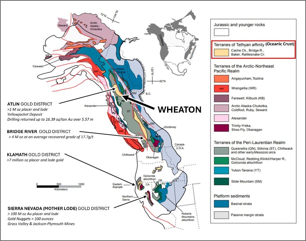
There have been no major orogenic lode gold deposits delineated to date within the northern Cache Creek terrane. However, several large placer gold camps have been established, commonly accompanied by hardrock showings and small gold deposits indicating potential sources of the rich surficial placers. Nearby examples of orogenic gold showings within the oceanic Cache Creek terrane include the Yellowjacket deposit (130,000 tonnes grading 5.8 g/t Au) situated in the Atlin Goldfields, and the Keystone Showing (historic drill intercepts include 9.1 g/t Au over 12.2 m within a quartz porphyry setting) in the Thibert placer district. Both of these are associated with quartz veining and listwanitic alteration.
The Erickson gold camp, ~100 km to the north-northwest, is not hosted by the Cache Creek terrane, but is surrounded by the McDame Creek coarse surficial placer gold deposits, where the second-largest placer gold nugget ever recorded in BC, weighing 72 troy oz, was discovered. At Erickson, which comprises several past-producing gold mines, lode gold is characterised by quartz veins hosted by listwanite. Average grades ranged from 10-20 g/t Au for a total of 315,000 oz Au mined historically. The Erickson camp includes the Taurus deposit, currently owned and being advanced by Cassiar Gold Corp., which has delineated an indicated resource of 0.4 Moz Au and an additional inferred resource of 1.9 Moz Au6.
Placer miners have reported that many of the placer gold nuggets recovered from the Peacock workings of Wheaton Creek, which directly drains the area of drill hole DDH-86-01, contain inclusions of altered pyroxene and serpentine, and that some gold nuggets are still fused to quartz fragments. These observations by the placer miners further suggest the placer gold in Wheaton Creek has a nearby source.

Maps

Address
Trailbreaker Resources Ltd.
650 W Georgia St # 2110
Vancouver, British Columbia
Canada, V6B 4N9