November 6, 2025 – Trailbreaker Resources Ltd. (TBK.V) (“Trailbreaker” or “the Company”) is announcing that it has amended an option agreement for a mineral claim at its Atsutla Gold project in northwestern British Columbia (BC).
The initial Option Agreement, dated November 21st, 2022, was signed with Mr. Torrey Fredlund (the “Optionor”) for Trailbreaker to obtain a 100% interest in his ‘Golden Echelon’ claim block located between the Snook and Highland zones. The claim block consists of one mineral claim covering 132 hectares (see November 28, 2022 news release).
The initial Option Agreement signed November 21st, 2022:
Trailbreaker can earn a 100% interest in the Golden Echelon claim by making staged share issuances totaling 80,000 common shares over three years and a making a one-time cash payment of $25,000 as follows:
10,000 common shares on receipt of TSX Venture Exchange approval;
10,000 common shares on or before November 16, 2023;
10,000 common shares on or before November 16, 2024; and
50,000 common shares and $25,000 cash payment on or before November 16, 2025.
The Optionor will retain a 1% Net Smelter Return (NSR) royalty and Trailbreaker has the right to buy back the 1% NSR within a two-year period from the exercise of the option for a cash payment of $50,000 and issuance of 100,000 common shares.
The Amending Agreement, signed November 3rd, 2025, has deleted paragraph d) of the above Option Agreement and replaced it with the following paragraphs d) and e):
d) issuing to the Optionor 25,000 common shares by November 16, 2025; and
e) on or before May 16, 2026, either:
i) paying to the Optionor $25,000 and issuing the Optionor 50,000 common shares; or
ii) issuing to the Optionor 175,000 common shares.
The Amending Agreement is subject to the approval of the TSX Venture Exchange.
About Trailbreaker Resources
Trailbreaker Resources is a mining exploration company focused primarily on mining-friendly British Columbia and Yukon Territory, Canada. Trailbreaker is committed to continuous exploration and research, allowing maintenance of a portfolio of quality mineral properties which in turn provides value for shareholders. The company has an experienced management team with a proven track record as explorers and developers throughout the Yukon Territory, British Columbia, Alaska and Nevada.
ON BEHALF OF THE BOARD
Daithi Mac Gearailt
President and Chief Executive Officer
Carl Schulze, P. Geo., Consulting Geologist with Aurora Geosciences Ltd, is a qualified person as defined by National Instrument 43-101 for Trailbreaker’s BC and Yukon exploration projects, and has reviewed and approved the technical information in this release.
Other
For new information about the Company’s projects, please visit Trailbreaker’s website at TrailbreakerResources.com and sign up to receive news. For further information, follow Trailbreaker’s tweets at Twitter.com/TrailbreakerLtd, use the ‘Contact’ section of our website, or contact us at (604) 681-1820 or at info@trailbreakerresources.com.
Neither the TSX Venture Exchange nor its Regulation Services Provider (as that term is defined in the policies of the TSX Venture Exchange) accepts responsibility for the adequacy or accuracy of this release.
Forward-Looking Statements
Statements contained in this news release that are not historical facts are “forward-looking information” or “forward-looking statements” (collectively, “Forward-Looking Information”) within the meaning of applicable Canadian securities legislation and the United States Private Securities Litigation Reform Act of 1995. Forward-Looking Information includes, but is not limited to, disclosure regarding possible events, conditions or financial performance that is based on assumptions about future economic conditions and courses of action; expectations regarding future exploration and drilling programs and receipt of related permitting. In certain cases, Forward-Looking Information can be identified by the use of words and phrases such as “anticipates”, “expects”, “understanding”, “has agreed to” or variations of such words and phrases or statements that certain actions, events or results “would”, “occur” or “be achieved”. Although Trailbreaker has attempted to identify important factors that could affect Trailbreaker and may cause actual actions, events or results to differ materially from those described in Forward-Looking Information, there may be other factors that cause actions, events or results not to be as anticipated, estimated or intended. In making the forward-looking statements in this news release, if any, Trailbreaker has applied several material assumptions, including the assumption that general business and economic conditions will not change in a materially adverse manner. There can be no assurance that Forward-Looking Information will prove to be accurate, as actual results and future events could differ materially from those anticipated in such statements. Accordingly, readers should not place undue reliance on Forward-Looking Information. Except as required by law, Trailbreaker does not assume any obligation to release publicly any revisions to Forward-Looking Information contained in this news release to reflect events or circumstances after the date hereof or to reflect the occurrence of unanticipated events.
September 22, 2025 – Trailbreaker Resources Ltd. (TBK.V) (“Trailbreaker” or “the Company”) is pleased to announce that an exploration team has been mobilized to its flagship Atsutla Gold project, located in northwestern British Columbia (BC).
Trailbreaker’s 100%-owned Atsutla Gold project is located 70 km south of the Yukon-British Columbia border and 120 km northwest of the Village of Dease Lake, BC. The project covers over 40,000 hectares (ha) of ground with very limited historic exploration.
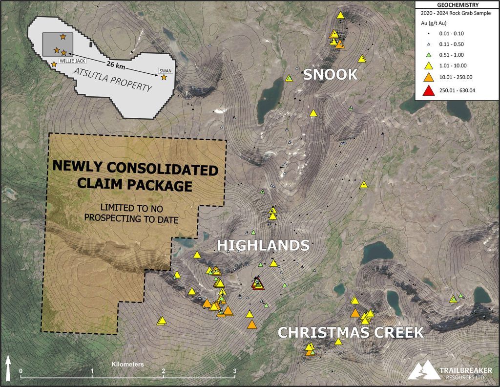
Over the past year, Trailbreaker has consolidated key ground within the Atsutla Gold project claim boundary, near the Highlands zone which hosts the highest gold grades sampled on the property to date (up to 630 g/t gold [Au]). The newly acquired ground consists of 528 ha, 396 ha of which were acquired by recent staking, and 132 ha acquired through a purchase agreement with a claim holder (details below). This area has yet to be explored for gold by the Company (Figure 1).
Trailbreaker’s team will be performing first-pass reconnaissance exploration on the new ground, including geological mapping, prospecting, and soil sampling. The team will also be ground-truthing drill collar locations within the Highlands zone area in preparation of a future drill program.
Daithi Mac Gearailt, CEO of Trailbreaker, commented,“Since its discovery in 2020, the Atsutla Gold project has remained Trailbreaker’s flagship property for good reason. Last year we advanced the Swan zone to a drill-ready stage, and we hope to do this same with the Highlands zone this year. We now have a significant piece of ground consolidated in the Highlands zone area which, to our knowledge, is virtually unexplored. I am looking forward to adding more to the Atsutla Gold project’s story.”
The Highlands zone hosts widespread gold mineralization with numerous rock grab samples returning multi-ounce gold and silver (Ag) values over a 750 x 600-metre area. The gold-bearing quartz veins are confined to shallow-dipping fault structures that have been traced for 3.5 km to the north (Snook zone) and 1.5 km to the east (Christmas Creek zone). This continuity suggests potential for additional mineralization within the newly consolidated ground west of the Highlands zone. Testing this theory is the primary goal of this exploration program.
The Atsutla Gold project is fully permitted for drilling, focusing on two separate targets representing distinct deposit settings, neither of which have ever been drilled. The Highlands zone represents a brand-new high-grade orogenic gold discovery, while the Swan zone, situated 26 km to southeast, represents a porphyry Cu (copper)-Au-Ag target.
Figure 1: Trailbreaker’s new, unexplored ground west of the Highlands zone.
Terms of the Purchase Agreement
On August 26th, 2025, Trailbreaker signed a purchase agreement with the claim holder of the aforementioned 132-ha parcel (the “Vendor”). Trailbreaker will pay the Vendor CAD $10,000 to obtain a 100% interest in the property. The Vendor will retain a total 2.0% Net Smelter Return (NSR) royalty, which may be brought down to 1.0% through a cash payment of $1,000,000 to the Vendor.
More about the Atsutla Gold project
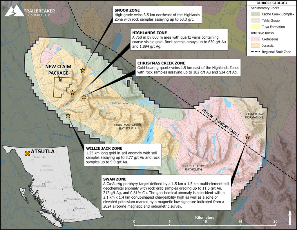
The Atsutla Gold project is centered over the regional-scale Teslin-Thibert fault system that marks the contact between the Quesnel and Cache Creek terranes. Gold mineralization is associated with Mesozoic batholitic intrusions that are the predominant geological unit on the property. Since discovery in 2020, Trailbreaker has outlined five significant zones of gold mineralization on the property, across a span of 26 kilometers (Figure 2). These are:
Highlands Zone – A 750 m by 600 m area in the western Atsutla Gold project region, with veins containing coarse visible gold and assaying up to 630 g/t Au and 1,894 g/t Ag.
Christmas Creek Zone – Gold-bearing quartz veins 1.5 km east of the Highlands Zone, with rock samples assaying up to 102 g/t Au and 524 g/t Ag.
Snook Zone – High-grade veins 3.5 km northeast of the Highlands Zone with rock samples assaying up to 53.3 g/t.
Swan Zone – A Cu-Au-Ag porphyry target defined by a 1.5 km x 1.5 km multi-element soil geochemical anomaly (Au-Cu-Ag-arsenic [As]-molybdenum [Mo]-antimony [Sb]-bismuth [Bi]), with rock grab samples grading up to 11. 11.7 g/t Au, 212 g/t Ag, and 0.81% Cu. The geochemical anomaly is coincident with a 2.1 km x 1.4 km donut-shaped chargeability high (defined by a 2024 induced polarization survey) as well as a zone of elevated potassium marked by a magnetic low signature indicated from a 2024 airborne magnetic and radiometric survey.
Figure 2: Geology and mineralized zones at the Atsutla Gold project.
About Trailbreaker Resources
Trailbreaker Resources is a mining exploration company focused primarily on mining-friendly British Columbia and Yukon Territory, Canada. Trailbreaker is committed to continuous exploration and research, allowing maintenance of a portfolio of quality mineral properties which in turn provides value for shareholders. The company has an experienced management team with a proven track record as explorers and developers throughout the Yukon Territory, British Columbia, Alaska and Nevada.
ON BEHALF OF THE BOARD
Daithi Mac Gearailt
President and Chief Executive Officer
Carl Schulze, P. Geo., Consulting Geologist with Aurora Geosciences Ltd, is a qualified person as defined by National Instrument 43-101 for Trailbreaker’s BC and Yukon exploration projects, and has reviewed and approved the technical information in this release.
Other
For new information about the Company’s projects, please visit Trailbreaker’s website at TrailbreakerResources.com and sign up to receive news. For further information, follow Trailbreaker’s tweets at Twitter.com/TrailbreakerLtd, use the ‘Contact’ section of our website, or contact us at (604) 681-1820 or at info@trailbreakerresources.com.
Neither the TSX Venture Exchange nor its Regulation Services Provider (as that term is defined in the policies of the TSX Venture Exchange) accepts responsibility for the adequacy or accuracy of this release.
Forward-Looking Statements
Statements contained in this news release that are not historical facts are “forward-looking information” or “forward-looking statements” (collectively, “Forward-Looking Information”) within the meaning of applicable Canadian securities legislation and the United States Private Securities Litigation Reform Act of 1995. Forward-Looking Information includes, but is not limited to, disclosure regarding possible events, conditions or financial performance that is based on assumptions about future economic conditions and courses of action; expectations regarding future exploration and drilling programs and receipt of related permitting. In certain cases, Forward-Looking Information can be identified by the use of words and phrases such as “anticipates”, “expects”, “understanding”, “has agreed to” or variations of such words and phrases or statements that certain actions, events or results “would”, “occur” or “be achieved”. Although Trailbreaker has attempted to identify important factors that could affect Trailbreaker and may cause actual actions, events or results to differ materially from those described in Forward-Looking Information, there may be other factors that cause actions, events or results not to be as anticipated, estimated or intended. In making the forward-looking statements in this news release, if any, Trailbreaker has applied several material assumptions, including the assumption that general business and economic conditions will not change in a materially adverse manner. There can be no assurance that Forward-Looking Information will prove to be accurate, as actual results and future events could differ materially from those anticipated in such statements. Accordingly, readers should not place undue reliance on Forward-Looking Information. Except as required by law, Trailbreaker does not assume any obligation to release publicly any revisions to Forward-Looking Information contained in this news release to reflect events or circumstances after the date hereof or to reflect the occurrence of unanticipated events.
September 15, 2025 – Trailbreaker Resources Ltd. (TBK.V) (“Trailbreaker” or “the Company”) is pleased to provide the following corporate update on its gold (Au), copper-gold (Cu-Au), and copper-molybdenum (Cu-Mo) projects in British Columbia (BC) and Yukon Territory.
Trailbreaker is currently focussed on three projects in BC: the Liberty Cu-Mo porphyry project and Coho Cu-Au porphyry project, both in central BC, the Atsutla high-grade Au and porphyry Cu-Au-silver (Ag) project in northwestern BC.
Atsutla Gold Project
The Atsutla Gold project is a newly discovered high-grade gold project 120 km northwest of Dease Lake, BC. In addition to high-grade vein-hosted gold, the project also hosts a Cu-Au-Ag porphyry target called the Swan zone, which was further outlined through geophysical surveying in 2024 (see October 7, 2024 news release). Over the past three months, Trailbreaker consolidated key ground within the Atsutla Gold property claim boundary, particularly near the Highlands zone which hosts the highest gold grades sampled on the property to date (up to 630 g/t Au in grab samples).
The Company plans to conduct a first-pass exploration program over the newly acquired ground by the end of this field season, in addition to ground-truthing of drill collar locations in preparation of a future drill program.
The Highlands zone hosts widespread gold mineralization with numerous rock grab samples returning multi-ounce gold and silver values over a 750 x 600-meter area. The gold-bearing quartz veins are confined to shallow-dipping fault structures that have been traced for 3.5 km to the north (Snook zone) and 2 km to the east (Christmas Creek zone). This continuity suggests potential for additional mineralization within the newly consolidated ground west of the Highlands zone. The team is excited to test this theory during the upcoming exploration program.
The Atsutla Gold project is fully permitted for drilling, focusing on two separate targets representing distinct deposit settings, neither of which have ever been drilled. The Highlands zone represents a brand-new high-grade orogenic gold discovery, while the Swan zone, situated 26 km to southeast, represents a porphyry Cu-Au-Ag target.
Liberty Cu-Mo Project
Throughout 2024 and 2025, Trailbreaker advanced its Liberty Cu-Mo porphyry project, located 60 km northwest of Quesnel, BC. In 2024, the Company completed a seven-hole, 2,442 m diamond drilling program followed-up by an extensive soil geochemical program, an induced polarization (IP) geophysical survey, and an airborne electromagnetic (ZTEM) survey. Throughout this process, the property was expanded twice through additional claim staking, increasing from 5,054 hectares to 9,453 hectares in size.
Favourable drill results and combined interpretation of the IP and ZTEM data defined a significant target area for a phase 2 drill program, which was initially planned for May-June, 2025 (see Jan 13, 2025 news release). However, due to the significant size increase of the claim package, and the magnitude of the planned drill program, additional archaeological studies and environmental assessments were required which have been completed and are currently under review. As such, approval for the drill permit has been delayed.
Coho Cu-Au Property
In May, 2025, Trailbreaker acquired the Coho property, a Cu-Au porphyry target located in central BC, 30 km west of the Mount Milligan mine, and directly adjacent to Pacific Ridge Exploration’s Chuchi Cu-Au porphyry deposit (see May 26, 2025 news release). The Company considers the Coho property to be one of the more advanced projects in its portfolio. The priority target, the Coho zone, has been advanced through recent IP and airborne electromagnetic (EM) surveys, and has never been drilled.
Due to the size and scope of the project, Trailbreaker is planning an aggressive drill program. The Company is currently modelling historic (2022-2023) geophysical data and is compiling historic geochemical data to aid in drill targeting. While the Coho property is currently permitted for drilling under the previous operator (Pacific Ridge Exploration Ltd.), Trailbreaker has chosen to apply for a new separate drill permit that will comprise a much larger scope of exploration. The new application is for a 5-year area-based permit that will include up to 50 drill sites. The permit process is well underway, and Trailbreaker is working closely with the BC government and local First Nations to finalize the process.
Other Projects
In July, 2025, Trailbreaker announced the acquisition of the Wheaton Gold property, an orogenic gold prospect located 60 km east of Dease Lake, BC (see July 7, 2025 news release). The property covers the headwaters of multiple placer gold-bearing creeks, including Alice Shea Creek, source of the famous 52- troy oz ‘Turnagain nugget’. The Company is currently mobilizing for a 2025 surface exploration program to test multiple targets on the project.
Trailbreaker is also pleased to announce that the drill permit for its Castle Rock property on Vancouver Island has been approved. The Castle Rock property is an early-stage Cu-Au porphyry prospect situated on northern Vancouver Island, approximately 70 km northwest of Campbell River, BC. The company has advanced the project through multiple surface exploration programs from 2022 to 2024 (see August 12, 2024 news release). The newly received 5-year area-based permit includes up to 40 drill sites and 40 line-km of ground geophysics (such as IP, magnetic, or EM). The Company is currently planning the next steps for this project.
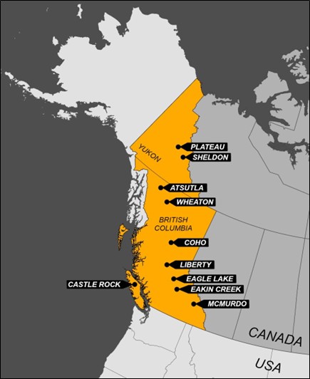
Trailbreaker remains committed to maintaining a pipeline of high-quality exploration projects throughout BC and the Yukon (Figure 1). These include McMurdo property near Golden, BC, the Eakin Creek property near Clearwater, BC, the Eagle Lake property east of Williams Lake, BC, the Sheldon property north of Ross River, YT, and the Plateau property east of Mayo, YT.
For more information on these projects, please visit the Projects Overview section on our website.
Figure 1: Location map of Trailbreaker’s exploration projects.
Message from the President
“A strong argument can be made that we are in the early stages of a new, multi-decade commodity bull market, and Trailbreaker Resources is very well-positioned to take advantage of this. We have an outstanding portfolio of new drill-ready projects, all of which have the potential of host significant discoveries. We have a good cash balance, an excellent share structure, and a team that continues to add valuable projects to our portfolio. I’d like to thank our loyal shareholders for their support, and I look forward to creating value for the company with future drilling once permits are in place.” – Daithi Mac Gearailt
About Trailbreaker Resources
Trailbreaker Resources is a mining exploration company focused primarily on mining-friendly British Columbia and Yukon Territory, Canada. Trailbreaker is committed to continuous exploration and research, allowing maintenance of a portfolio of quality mineral properties which in turn provides value for shareholders. The company has an experienced management team with a proven track record as explorers and developers throughout the Yukon Territory, British Columbia, Alaska and Nevada.
ON BEHALF OF THE BOARD
Daithi Mac Gearailt
President and Chief Executive Officer
Carl Schulze, P. Geo., Consulting Geologist with Aurora Geosciences Ltd, is a qualified person as defined by National Instrument 43-101 for Trailbreaker’s BC and Yukon exploration projects, and has reviewed and approved the technical information in this release.
Other
For new information about the Company’s projects, please visit Trailbreaker’s website at TrailbreakerResources.com and sign up to receive news. For further information, follow Trailbreaker’s tweets at Twitter.com/TrailbreakerLtd, use the ‘Contact’ section of our website, or contact us at (604) 681-1820 or at info@trailbreakerresources.com.
Neither the TSX Venture Exchange nor its Regulation Services Provider (as that term is defined in the policies of the TSX Venture Exchange) accepts responsibility for the adequacy or accuracy of this release.
Forward-Looking Statements
Statements contained in this news release that are not historical facts are “forward-looking information” or “forward-looking statements” (collectively, “Forward-Looking Information”) within the meaning of applicable Canadian securities legislation and the United States Private Securities Litigation Reform Act of 1995. Forward-Looking Information includes, but is not limited to, disclosure regarding possible events, conditions or financial performance that is based on assumptions about future economic conditions and courses of action; expectations regarding future exploration and drilling programs and receipt of related permitting. In certain cases, Forward-Looking Information can be identified by the use of words and phrases such as “anticipates”, “expects”, “understanding”, “has agreed to” or variations of such words and phrases or statements that certain actions, events or results “would”, “occur” or “be achieved”. Although Trailbreaker has attempted to identify important factors that could affect Trailbreaker and may cause actual actions, events or results to differ materially from those described in Forward-Looking Information, there may be other factors that cause actions, events or results not to be as anticipated, estimated or intended. In making the forward-looking statements in this news release, if any, Trailbreaker has applied several material assumptions, including the assumption that general business and economic conditions will not change in a materially adverse manner. There can be no assurance that Forward-Looking Information will prove to be accurate, as actual results and future events could differ materially from those anticipated in such statements. Accordingly, readers should not place undue reliance on Forward-Looking Information. Except as required by law, Trailbreaker does not assume any obligation to release publicly any revisions to Forward-Looking Information contained in this news release to reflect events or circumstances after the date hereof or to reflect the occurrence of unanticipated events.
July 25, 2025 – Trailbreaker Resources Ltd. (TBK.V) (“Trailbreaker” or “the Company”) is pleased to announce that the TSX Venture stock exchange (the “Exchange”) has approved the option agreement for Trailbreaker to acquire a 100% interest in the Wheaton Gold property, northwestern British Columbia (BC).
The 2,223-hectare Wheaton Gold property is located 60 km east of Dease Lake, BC, and covers the headwaters of multiple placer gold-bearing creeks, including Alice Shea Creek, source of the famous 52 troy oz ‘Turnagain nugget’. Details of the project can be found in Trailbreaker’s July 7th, 2025 news release.
Terms of the Option Agreement
On July 1st, 2025 (the “Effective Date”), Trailbreaker signed an option agreement (the “Agreement”) with Cordilleran Properties (the “Optionor”) of Kamloops, BC. Subject to the approval of the TSX Venture Exchange, Trailbreaker has the option to acquire a 100% interest in the Wheaton Gold property by completing the following:
paying to the Optionor $10,000 on the Effective Date;
paying to the Optionor $10,000 on or before the first anniversary of the Effective Date;
paying to the Optionor $15,000 on or before the second anniversary of the Effective Date;
paying to the Optionor $25,000 or issuing to the Optionor $25,000 worth of Trailbreaker common shares (“Shares”) on or before the third anniversary of the Effective Date;
paying to the Optionor $75,000 or issuing to the Optionor $75,000 worth of Shares on or before the fourth anniversary of the Effective Date; and
completing $1,000,000 of expenditures on or before the fifth anniversary of the Effective Date.
A maximum of 2,000,000 common shares will be issued at a deemed price per share equal to the greater of CDN$0.05 and the VWAP for the ten (10) trading days prior to issuance pursuant to this arms-length transaction.
Upon completion of the Agreement, Trailbreaker will obtain a 100% interest in the property and the Optionor will retain a total 2.0% Net Smelter Return (NSR) royalty, which may be brought down to 0.5% through a cash payment of $1,500,000 to the Optionor.
For more information about the Wheaton Gold property see the July 7, 2025 news release or the Wheaton Gold section on Trailbreaker’s webpage:
Trailbreaker Resources is a mining exploration company focused primarily on mining-friendly British Columbia and Yukon Territory, Canada. Trailbreaker is committed to continuous exploration and research, allowing maintenance of a portfolio of quality mineral properties which in turn provides value for shareholders. The company has an experienced management team with a proven track record as explorers and developers throughout the Yukon Territory, British Columbia, Alaska and Nevada.
ON BEHALF OF THE BOARD
Daithi Mac Gearailt
President and Chief Executive Officer
Carl Schulze, P. Geo., Consulting Geologist with Aurora Geosciences Ltd, is a qualified person as defined by National Instrument 43-101 for Trailbreaker’s BC and Yukon exploration projects, and has reviewed and approved the technical information in this release.
Other
For new information about the Company’s projects, please visit Trailbreaker’s website at TrailbreakerResources.com and sign up to receive news. For further information, follow Trailbreaker’s tweets at Twitter.com/TrailbreakerLtd, use the ‘Contact’ section of our website, or contact us at (604) 681-1820 or at info@trailbreakerresources.com.
Neither the TSX Venture Exchange nor its Regulation Services Provider (as that term is defined in the policies of the TSX Venture Exchange) accepts responsibility for the adequacy or accuracy of this release.
Forward-Looking Statements
Statements contained in this news release that are not historical facts are “forward-looking information” or “forward-looking statements” (collectively, “Forward-Looking Information”) within the meaning of applicable Canadian securities legislation and the United States Private Securities Litigation Reform Act of 1995. Forward-Looking Information includes, but is not limited to, disclosure regarding possible events, conditions or financial performance that is based on assumptions about future economic conditions and courses of action; expectations regarding future exploration and drilling programs and receipt of related permitting. In certain cases, Forward-Looking Information can be identified by the use of words and phrases such as “anticipates”, “expects”, “understanding”, “has agreed to” or variations of such words and phrases or statements that certain actions, events or results “would”, “occur” or “be achieved”. Although Trailbreaker has attempted to identify important factors that could affect Trailbreaker and may cause actual actions, events or results to differ materially from those described in Forward-Looking Information, there may be other factors that cause actions, events or results not to be as anticipated, estimated or intended. In making the forward-looking statements in this news release, if any, Trailbreaker has applied several material assumptions, including the assumption that general business and economic conditions will not change in a materially adverse manner. There can be no assurance that Forward-Looking Information will prove to be accurate, as actual results and future events could differ materially from those anticipated in such statements. Accordingly, readers should not place undue reliance on Forward-Looking Information. Except as required by law, Trailbreaker does not assume any obligation to release publicly any revisions to Forward-Looking Information contained in this news release to reflect events or circumstances after the date hereof or to reflect the occurrence of unanticipated events.
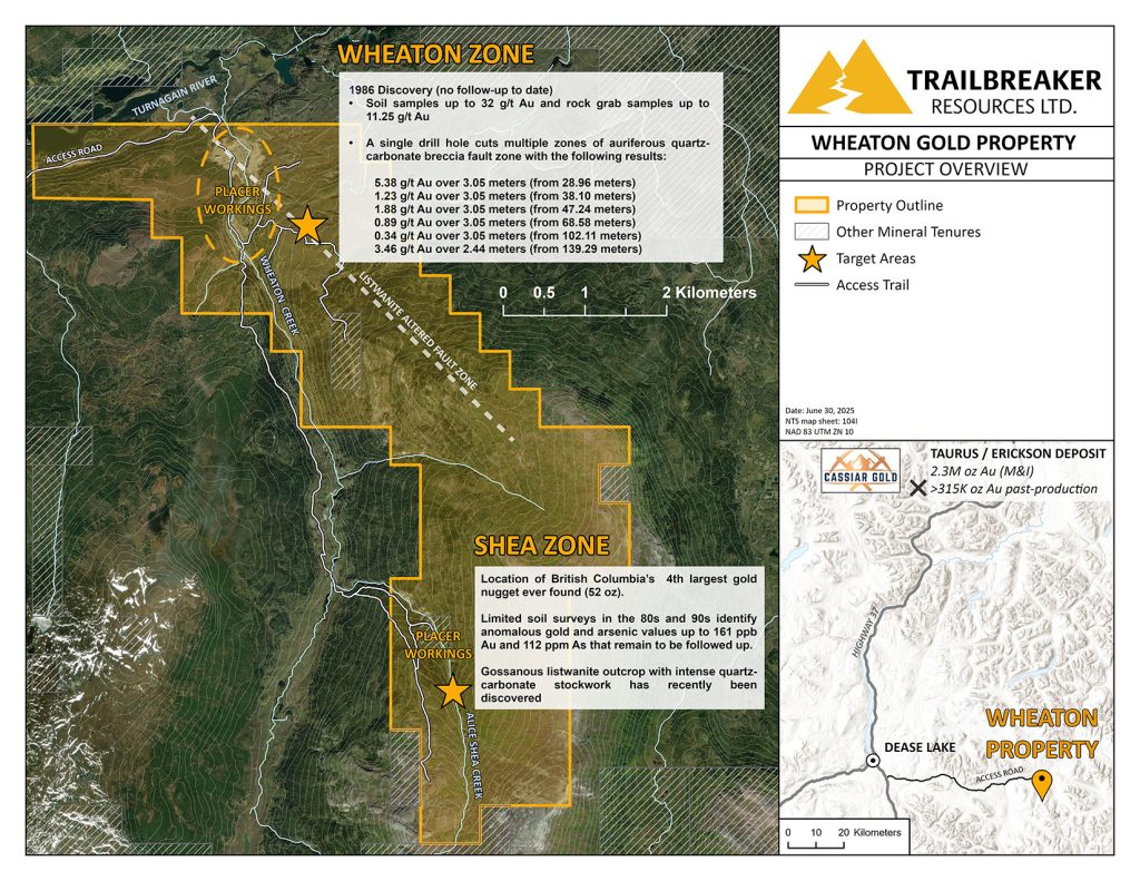
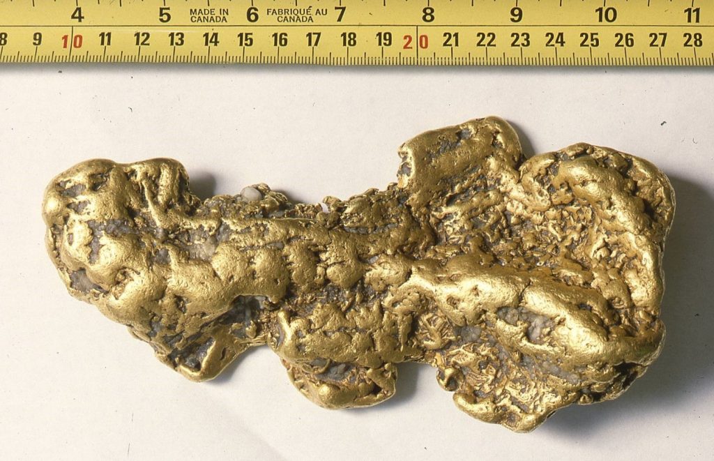
July 7, 2025 – Trailbreaker Resources Ltd. (TBK.V) (“Trailbreaker” or “the Company”) is pleased to announce the acquisition of the Wheaton Gold property, an orogenic gold prospect located 60 km east of the Village of Dease Lake, British Columbia (BC). The property covers the headwaters of multiple placer gold-bearing creeks, including Alice Shea Creek, source of the famous 52 troy oz ‘Turnagain nugget’.
Highlights of the Wheaton Gold Property
2,223 hectares in size, covering roughly 2 km x 9 km (Figure 1).
Located 60 km east of Dease Lake, BC, with extensive truck and ATV trail access throughout the claims, servicing historic and current placer mining operations.
Covers the headwaters of the placer gold-bearing Wheaton and Alice Shea creeks, which are famous as the source of some of BC’s coarsest gold nuggets. This includes the fourth largest nugget ever found in BC, the ‘Turnagain nugget’, weighing 52 oz gold (Au) (Figure 2)1.
The project represents one of BC’s most underexplored placer gold districts, with very limited hardrock exploration work done to date.
A three-hole, 304.7-meter diamond drill program completed in 1986 yielded numerous gold intercepts, including 5.38 g/t Au over 3.05 m (from 28.96m depth)2.
Historic gold-in-soil values up to 32.3 g/t Au, and historic rock grab samples up to 11.25 g/t Au3, have been returned.
Daithi Mac Gearailt, CEO of Trailbreaker, commented:“We are excited to add the Wheaton Gold property to our portfolio of gold and copper exploration projects. Now that the claims have been consolidated, this is a great opportunity to explore the area of a historic discovery hole that has yet to receive follow-up exploration. This is one of the few placer districts left in BC where a hardrock source of the placer gold has yet to be found. We are currently designing a robust exploration program and will be providing updates as soon as they are available.”
Location and Access
The 2,223-hectare Wheaton Gold property is located approximately 60 kilometers east-southeast of the Village of Dease Lake in northwestern British Columbia and can be accessed by all-terrain vehicles utilizing the Boulder Mine Road. The property can also be accessed by float plane chartered from Dease Lake to Boulder City Lake. Historic placer mining trails provide good vehicle access to much of the property.
Giga Metals Corporation has proposed a major road and transmission line to its advance-stage Turnagain nickel-cobalt deposit, located 10 km to the east. This would bisect the northern end of the Wheaton Gold property, further bolstering the potential economic viability of the area.
Figure 1: Location of the Wheaton Gold property with historic exploration highlights.
Placer Mining History
Placer gold was first discovered at the mouth of Wheaton Creek (formerly Boulder Creek) in 1932 and shortly afterwards on Alice Shea Creek, a small tributary of Wheaton Creek. The Wheaton-Shea placer camp marked the last major placer gold discovery in BC, with a total of 7,756 oz of placer gold mined from Wheaton Creek between 1932 and 1945, and a total of 331 oz Au mined from Alice Shea between 1936 and 1940. Alice Shea Creek produced the coarsest placer gold in the drainage, with one nugget weighing over 52 oz (the Turnagain nugget, Figure 2) and numerous nuggets weighing from 1 to 16 oz. Modern-day placer mining continues to this day at the mouth of Wheaton Creek, with over 20,000 oz of placer gold estimated to be recovered to date.
Figure 2: The 52 oz Turnagain nugget, discovered in Alice Shea Creek in 19371.
Hardrock Exploration History
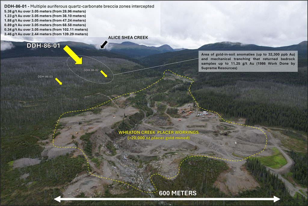
Wheaton Zone
The northern portion of the property, covering the present-day placer operations near the mouth of Wheaton Creek, has seen the least amount of hardrock exploration within the property, having undergone only one documented significant program, completed in 1986 by Supreme Resources (Supreme). That year, Supreme conducted a soil geochemical survey followed by a mechanical trenching program which returned very encouraging results, and identified strongly anomalous gold-in-soil values up to 32,300 ppb Au. Trenching within these soil anomalies returned rock gab samples up to 11.25 g/t Au. During the same year, Supreme tested this zone with 3 shallow diamond drill holes totaling 304.7 meters (Figure 3). However, only limited follow-up work in the last 39 years has been documented.
Hole DDH-86-01, the first of the 1986 program, encountered several gold-enriched intervals associated with fault-controlled quartz-carbonate breccia, including:
5.38 g/t Au over 3.05 meters (from 28.96 meters)
1.23 g/t Au over 3.05 meters (from 38.10 meters)
1.88 g/t Au over 3.05 meters (from 47.24 meters)
0.89 g/t Au over 3.05 meters (from 68.58 meters)
0.34 g/t Au over 3.05 meters (from 102.11 meters)
3.46 g/t Au over 2.44 meters (from 139.29 meters)
The other two holes underwent very limited sampling, with only two samples taken from DDH-86-02 and one from DDH-86-03, all returning trace gold values.
This work by Supreme resulted in the first and only discovery of hardrock gold mineralization that could be linked to the source of the rich placer gold deposits along the lower portion of Wheaton Creek.
Figure 3: Location of the 1986 diamond drill program above Wheaton Creek.
Pacific Bay Minerals, a junior mining company, held the ground from 2015 to 2024 but conducted very limited exploration. Much of Pacific Bay’s efforts were focused on mining jade boulders rather than on hardrock gold exploration. Their most significant work included a 2021 property-wide airborne magnetic survey that defined an open-ended NW-SE trending linear magnetic low feature that correlates with the 1986 discovery hole by Supreme. This is interpreted to potentially represent a listwanite-altered fault zone (Figure 4). Listwanite and listwanitic alteration is extensively documented around Alice Shea Creek (expanded upon below).
This survey provided several new exploration targets which have not been tested to date. Several east-west trending offsets occurring near the Wheaton zone may represent potential structures associated with gold mineralization.
Figure 4: The 2021 airborne magnetic survey completed by Pacific Bay Minerals displays a significant NW-SE trending magnetic low which is interpreted to be a listwanite-altered fault zone. The 1986 drilling is located on the margin of this zone.
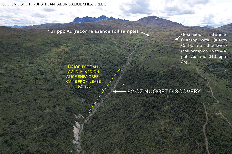
Shea Zone
The Shea zone is located along the headwaters of Alice Shea creek, close to the discovery area of the 52 oz Turnagain gold nugget. The nugget was discovered in the upper extent of the drainage, narrowing the search for the hardrock source.
The majority of the exploration work done at the Shea zone was done from 1985 to 1996, with several junior mining companies conducting small-scale exploration surveys. This includes companies such as Powder Ridge Resources, Imperial Metals, Goldbank Ventures, and Loumic Resources.
Loumic Resources’ 1996 exploration program was the most robust, comprising 196 soil samples and 191 meters of mechanized trenching4. Reconnaissance soil sampling identified several anomalous gold-arsenic (As) zones (up to 161 ppb Au & 112 ppm As) that have yet to receive follow-up exploration (Figure 5). Furthermore, trenching, targeting gossanous float immediately upslope from the location of the 52 oz gold nugget, revealed a listwanite outcrop containing intense quartz stockwork and disseminated pyrite. Only trace gold values were returned; however, the mineralization and alteration are textbook markers for orogenic gold deposits. This marked the last significant gold exploration program occurring on the Shea zone.
In 2011, First Point Minerals Corp was the last junior mining company to work the property; however, they focused on nickel mineralization rather than gold. Gold analysis for rock grab samples during the 2011 program utilized a 4 g/t detection limit, much higher than fire assay detection limits commonly used.
Figure 5: Historic hardrock exploration along Alice Shea Creek, with the approximate location of the discovery of the 52 oz Turnagain nugget.
Geology, Deposit Model, and Mineralization
The Wheaton Gold property is underlain by northwest-trending, complexly folded and faulted ultramafic rocks of the oceanic Cache Creek terrane, and by metasedimentary rocks of the Kedahda Formation (Figure 6).
The northern portion of the Wheaton Gold property covers fault-bounded metasedimentary rocks of the Mississippian to Triassic Kedahda formation which include heterolithic argillite with wispy silt laminae, thinly bedded sandstone, and rare discontinuous limestone beds. This Kedahda sedimentary package is separated from the ultramafic rocks (peridotite, dunite, pyroxenite) of the Cache Creek terrane by a northwest-southeast trending thrust fault.
Figure 6: Regional geology and neighbouring projects of the Wheaton Gold property.
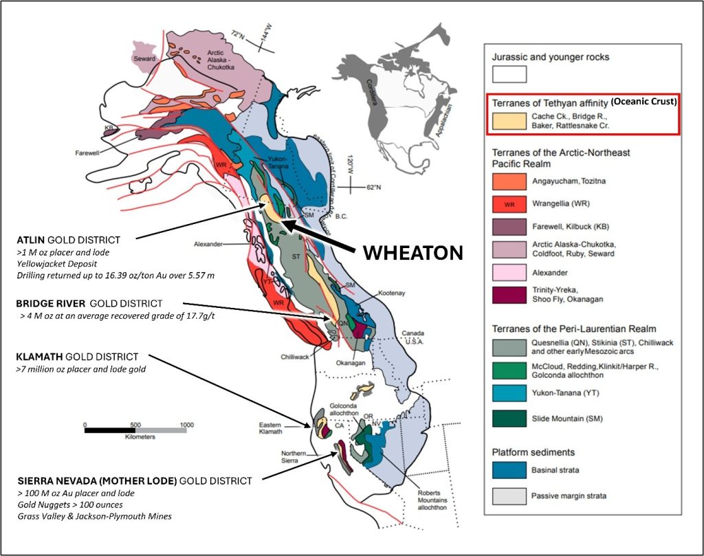
The Wheaton Gold property demonstrates potential for orogenic “motherlode-style” Au-bearing quartz vein deposits, such as the past-producing 4.2 Moz Bralorne-Pioneer mine in the Bridge Lake Gold Camp, southwestern British Columbia, and the world-famous Sierra Nevada mining district in California which produced over 100 Moz of placer and hardrock ‘lode’ gold (Figure 7). The Wheaton Gold property is analogous to these deposits, as all are hosted by oceanic crust accreted onto ancestral North America and spatially associated with significant coarse placer gold deposits. Furthermore, the lode gold deposits at both the Bridge Lake and Sierra Nevada gold districts are associated with listwanitic alteration of peridotites, quartz veining, and major fault structures, all of which have also been mapped in the Wheaton property area.
Figure 7: Orogenic lode gold camps along the Cordillera (modified from Nelson et al., 20135).
There have been no major orogenic lode gold deposits delineated to date within the northern Cache Creek terrane. However, several large placer gold camps have been established, commonly accompanied by hardrock showings and small gold deposits indicating potential sources of the rich surficial placers. Nearby examples of orogenic gold showings within the oceanic Cache Creek terrane include the Yellowjacket deposit (130,000 tonnes grading 5.8 g/t Au) situated in the Atlin Goldfields, and the Keystone Showing (historic drill intercepts include 9.1 g/t Au over 12.2 m within a quartz porphyry setting) in the Thibert placer district. Both of these are associated with quartz veining and listwanitic alteration.
The Erickson gold camp, ~100 km to the north-northwest, is not hosted by the Cache Creek terrane, but is surrounded by the McDame Creek coarse surficial placer gold deposits, where the second-largest placer gold nugget ever recorded in BC, weighing 72 oz, was discovered. At Erickson, which comprises several past-producing gold mines, lode gold is characterised by quartz veins hosted by listwanite. Average grades ranged from 10-20 g/t Au for a total of 315,000 oz Au mined historically. The Erickson camp includes the Taurus deposit, currently owned and being advanced by Cassiar Gold Corp., which has delineated an indicated resource of 0.4 Moz Au and an additional inferred resource of 1.9 Moz Au6.
Placer miners have reported that many of the placer gold nuggets recovered from the Peacock workings of Wheaton Creek, which directly drains the area of drill hole DDH-86-01, contain inclusions of altered pyroxene and serpentine, and that some gold nuggets are still fused to quartz fragments. These observations by the placer miners further suggest the placer gold in Wheaton Creek has a nearby source.
Terms of the Option Agreement
On July 1st, 2025 (the “Effective Date”), Trailbreaker signed an option agreement (the “Agreement”) with Cordilleran Properties (the “Optionee”) of Kamloops, BC. Subject to the approval of the TSX Venture Exchange, Trailbreaker has the option to acquire a 100% interest in the Wheaton Gold property by completing the following:
paying to the Optionee $10,000 on the Effective Date;
paying to the Optionee $10,000 on or before the first anniversary of the Effective Date;
paying to the Optionee $15,000 on or before the second anniversary of the Effective Date;
paying to the Optionee $25,000 or issuing to the Optionee $25,000 worth of Trailbreaker common shares (“Shares”) on or before the third anniversary of the Effective Date;
paying to the Optionee $75,000 or issuing to the Optionee $75,000 worth of Shares on or before the fourth anniversary of the Effective Date; and
completing $1,000,000 of expenditures on or before the fifth anniversary of the Effective Date.
Upon completion of the Agreement, Trailbreaker will obtain a 100% interest in the property and the Optionee will retain a total 2.0% Net Smelter Return (NSR) royalty, which may be brought down to 0.5% through a cash payment of $1,500,000 to the Optionee.
Nelson, J.L., Colpron, M., and Israel, S., 2013, The Cordillera of British Columbia, Yukon, and Alaska: Tectonics and metallogeny, in Colpron, M., Bissig, T., Rusk, B.G., and Thompson, J.F.H., eds., Tectonics, Metallogeny, and Discovery: The North American Cordillera and Similar Accretionary Settings: Society of Economic Geologists Special Publication 17, p. 53–109.
Trailbreaker Resources is a mining exploration company focused primarily on mining-friendly British Columbia and Yukon Territory, Canada. Trailbreaker is committed to continuous exploration and research, allowing maintenance of a portfolio of quality mineral properties which in turn provides value for shareholders. The company has an experienced management team with a proven track record as explorers and developers throughout the Yukon Territory, British Columbia, Alaska and Nevada.
ON BEHALF OF THE BOARD
Daithi Mac Gearailt
President and Chief Executive Officer
Carl Schulze, P. Geo., Consulting Geologist with Aurora Geosciences Ltd, is a qualified person as defined by National Instrument 43-101 for Trailbreaker’s BC and Yukon exploration projects, and has reviewed and approved the technical information in this release.
Other
For new information about the Company’s projects, please visit Trailbreaker’s website at TrailbreakerResources.com and sign up to receive news. For further information, follow Trailbreaker’s tweets at Twitter.com/TrailbreakerLtd, use the ‘Contact’ section of our website, or contact us at (604) 681-1820 or at info@trailbreakerresources.com.
Neither the TSX Venture Exchange nor its Regulation Services Provider (as that term is defined in the policies of the TSX Venture Exchange) accepts responsibility for the adequacy or accuracy of this release.
Forward-Looking Statements
Statements contained in this news release that are not historical facts are “forward-looking information” or “forward-looking statements” (collectively, “Forward-Looking Information”) within the meaning of applicable Canadian securities legislation and the United States Private Securities Litigation Reform Act of 1995. Forward-Looking Information includes, but is not limited to, disclosure regarding possible events, conditions or financial performance that is based on assumptions about future economic conditions and courses of action; expectations regarding future exploration and drilling programs and receipt of related permitting. In certain cases, Forward-Looking Information can be identified by the use of words and phrases such as “anticipates”, “expects”, “understanding”, “has agreed to” or variations of such words and phrases or statements that certain actions, events or results “would”, “occur” or “be achieved”. Although Trailbreaker has attempted to identify important factors that could affect Trailbreaker and may cause actual actions, events or results to differ materially from those described in Forward-Looking Information, there may be other factors that cause actions, events or results not to be as anticipated, estimated or intended. In making the forward-looking statements in this news release, if any, Trailbreaker has applied several material assumptions, including the assumption that general business and economic conditions will not change in a materially adverse manner. There can be no assurance that Forward-Looking Information will prove to be accurate, as actual results and future events could differ materially from those anticipated in such statements. Accordingly, readers should not place undue reliance on Forward-Looking Information. Except as required by law, Trailbreaker does not assume any obligation to release publicly any revisions to Forward-Looking Information contained in this news release to reflect events or circumstances after the date hereof or to reflect the occurrence of unanticipated events.
June 5, 2025 – Trailbreaker Resources Ltd. (TBK.V) (“Trailbreaker” or “the Company”) is pleased to announce that the TSX Venture stock exchange (the “Exchange”) has approved the option agreement for Trailbreaker to acquire a 100% interest in the Coho property, central British Columbia (BC).
The 8,000-hectare Coho property covers a copper-gold (Cu-Au) porphyry target located 90 km north of Fort St. James, BC, and 30 km west of the Mount Milligan mine. Historically named the Chuchi South property, Trailbreaker renamed the project as the Coho property when the Company announced the acquisition on May 26, 2025 (see news release).
Terms of the Option Agreement
On May 15th, 2025, Trailbreaker signed an option agreement (the “Agreement”) with Ron Bilquist (“Bilquist”) of Gabriola, BC. Subject to the approval of the Exchange, Trailbreaker has the option to acquire a 100% interest in the Coho property if the following terms are met:
(a) pay to Bilquist an aggregate $380,000 as follows:
(i) $20,000 on execution of this Agreement;
(ii) an additional $25,000 on or before May 20, 2026;
(iii) an additional $35,000 on or before May 20, 2027;
(iv) an additional $50,000 on or before May 20, 2028;
(v) an additional $50,000 on or before May 20, 2029;
(vi) an additional $200,000 on or before May 20, 2030; and
(b) issue and deliver to Bilquist an aggregate 700,000 Trailbreaker common shares (“Shares”) as follows:
(i) 50,000 Shares within 10 days of the date of Regulatory Approval;
(ii) an additional 100,000 Shares on or before May 20, 2026;
(iii) an additional 150,000 Shares on or before May 20, 2027;
(iv) an additional 200,000 Shares on or before May 20, 2028;
(v) an additional 200,000 Shares on or before May 20, 2029; and
(c) complete Expenditures on the Property of $200,000 as follows:
(i) $200,000 of Expenditures on or before May 20, 2027; and
(ii) Expenditures (including the Expenditures referred to in (i) above) of $1 million or
1,500 metres of diamond drilling within 3 years of receiving a drill permit
Upon completion of the Agreement, Trailbreaker will obtain a 100% interest in the property and Bilquist will retain a total 2.0% Net Smelter Return (NSR) royalty, which may be brought down to 0.5% through a cash payment of $1,500,000 to Bilquist.
Upon completion of a bankable feasibility study, Trailbreaker shall pay to Bilquist $1,500,000.
Commencing on May 20, 2032, Trailbreaker shall pay to Bilquist annually $30,000 as an advance payment against the royalty, such payments to be credited against the royalty once the property goes into commercial production.
For more information about the Coho property see the May 26, 2025 news release or the Coho section on Trailbreaker’s webpage:
Trailbreaker Resources is a mining exploration company focused primarily on mining-friendly British Columbia and Yukon Territory, Canada. Trailbreaker is committed to continuous exploration and research, allowing maintenance of a portfolio of quality mineral properties which in turn provides value for shareholders. The company has an experienced management team with a proven track record as explorers and developers throughout the Yukon Territory, British Columbia, Alaska and Nevada.
ON BEHALF OF THE BOARD
Daithi Mac Gearailt
President and Chief Executive Officer
Carl Schulze, P. Geo., Consulting Geologist with Aurora Geosciences Ltd, is a qualified person as defined by National Instrument 43-101 for Trailbreaker’s BC and Yukon exploration projects, and has reviewed and approved the technical information in this release.
Other
For new information about the Company’s projects, please visit Trailbreaker’s website at TrailbreakerResources.com and sign up to receive news. For further information, follow Trailbreaker’s tweets at Twitter.com/TrailbreakerLtd, use the ‘Contact’ section of our website, or contact us at (604) 681-1820 or at info@trailbreakerresources.com.
Neither the TSX Venture Exchange nor its Regulation Services Provider (as that term is defined in the policies of the TSX Venture Exchange) accepts responsibility for the adequacy or accuracy of this release.
Forward-Looking Statements
Statements contained in this news release that are not historical facts are “forward-looking information” or “forward-looking statements” (collectively, “Forward-Looking Information”) within the meaning of applicable Canadian securities legislation and the United States Private Securities Litigation Reform Act of 1995. Forward-Looking Information includes, but is not limited to, disclosure regarding possible events, conditions or financial performance that is based on assumptions about future economic conditions and courses of action; expectations regarding future exploration and drilling programs and receipt of related permitting. In certain cases, Forward-Looking Information can be identified by the use of words and phrases such as “anticipates”, “expects”, “understanding”, “has agreed to” or variations of such words and phrases or statements that certain actions, events or results “would”, “occur” or “be achieved”. Although Trailbreaker has attempted to identify important factors that could affect Trailbreaker and may cause actual actions, events or results to differ materially from those described in Forward-Looking Information, there may be other factors that cause actions, events or results not to be as anticipated, estimated or intended. In making the forward-looking statements in this news release, if any, Trailbreaker has applied several material assumptions, including the assumption that general business and economic conditions will not change in a materially adverse manner. There can be no assurance that Forward-Looking Information will prove to be accurate, as actual results and future events could differ materially from those anticipated in such statements. Accordingly, readers should not place undue reliance on Forward-Looking Information. Except as required by law, Trailbreaker does not assume any obligation to release publicly any revisions to Forward-Looking Information contained in this news release to reflect events or circumstances after the date hereof or to reflect the occurrence of unanticipated events.