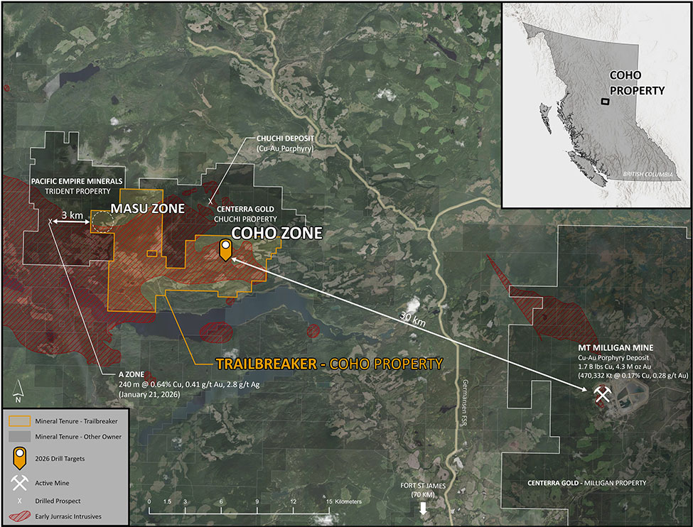
June 8, 2026 – Trailbreaker Resources Ltd. (TBK.V) (“Trailbreaker” or “the Company”) is pleased to announce that it has mobilized a field team to its Coho property in central British Columbia (BC) to begin a surface exploration program in advance of its upcoming September 2026 drill campaign. The program has two priorities: reconnaissance exploration along the property’s underexplored western boundary (the ‘Masu zone’), and ground-truthing of drill hole locations at the Coho zone, a copper-gold (Cu-Au) porphyry target.
Daithi Mac Gearailt, CEO of Trailbreaker, commented,“The Coho Cu-Au porphyry target represents a compelling opportunity, and we’re moving purposely toward our September drill program. Our field team is on the ground now, ground-truthing drill locations and systematically sampling territory that has had very little historic exploration. We believe this is shaping up to be an exciting period for Trailbreaker and our shareholders.”
Trailbreaker’s 8,000-hectare Coho property is located 90 km north of the Town of Fort St. James, BC and 30 km west of the Mt. Milligan Cu-Au porphyry deposit. The surface exploration program will be conducted at the Masu zone, located along the western boundary of the Coho property (see Figure 1). This program will follow up on results released by Pacific Empire Minerals (‘PEMC’) in January 2026 on the Trident property, which is contiguous with Coho’s western border. Drilling at the Trident property’s ‘A zone’ returned results including 240.0 m of 0.64% Cu, 0.41 g/t Au, and 2.8 g/t silver (Ag)1. The Masu zone is located 3.3 km east of the A zone*. The proposed surface exploration program will consist of prospecting, geological mapping, and a grid soil geochemical survey.
On May 25, 2026, Trailbreaker announced plans to drill the property’s primary target, the Coho zone, with an inaugural diamond drill program to commence in September 2026. The Coho zone is a Cu-Au porphyry target with recently completed property-wide geochemical and geophysical surveys. The zone hosts a recently identified coincident chargeability and resistivity anomaly, associated with high-grade gold and copper values from surface rock grab samples. Concurrent to exploring the Masu zone, Trailbreaker geologists will ground-truth proposed drill locations at the Coho zone and perform further geological mapping.
Figure 1: Locations of the Masu zone (site of the current surface exploration program), and Coho zone (site of the scheduled September 2026 drill program).
The 8,000-hectare Coho property was acquired by Trailbreaker through an option agreement signed in May 2025 whereby Trailbreaker has the option to acquire a 100% interest (see May 26, 2025 news release). The priority target is the Coho zone, a drill-ready Cu-Au porphyry target with recently completed property-wide geochemical and geophysical surveys. The zone hosts a recently identified coincident chargeability and resistivity anomaly, associated with high-grade gold and copper values from surface rock grab samples. While there has been limited historical drilling on the claims, the actual Coho zone has never been drilled.
Located within the Quesnel tectonic terrane, the Coho property is situated in a district known for prolific alkalic Cu-Au porphyry deposits and prospects. The property is located 30 km west of Centerra Gold’s Mount Milligan Cu-Au porphyry deposit, a producing mine with current reserves of 1.7 B lbs Cu and 4.3 Moz Au (470,332 kt grading 0.17% Cu and 0.28 g/t Au)2. To the north lies Pacific Ridge Resources’ Chuchi property, where 2024 drilling returned 382.0 m of 0.19% Cu, 0.12 g/t Au, and 0.47 g/t Ag3 from the BP zone.
The Coho zone is defined by a 650 m x 550 m Cu-Au-Ag surface rock and soil geochemical anomaly within diorite, and is spatially associated with an ENE-trending fault zone (the Coho fault) and gabbro dykes. Two additional faults, the Valley and Redline faults, extend south from the BP zone (Chuchi property) onto the Coho property and converge with the Coho fault at the Coho zone. Historic surface grab samples at the Coho zone returned values up to 16.15 g/t Au, 16.35% Cu, and 67.3 g/t Ag.
A recent (2022) airborne ZTEM (Z-axis Tipper electromagnetic) survey centered on the Coho zone, followed by a 2023 ground-based induced polarization (IP) survey, identified an interpreted 400 m x 250 m x 200 m-deep porphyry intrusive complex (3D ZTEM anomaly) with a two-limbed IP chargeability high anomaly that spans more than 1.4 km.
The Coho zone is located 4.5 km south of the BP zone (Chuchi property) and is currently interpreted to be situated along the same Valley/Redline fault structure that hosts the BP zone. Alkalic porphyry deposits commonly occur in clusters and Trailbreaker’s team believes the Coho property, in particular the Coho zone, may represent a Cu-Au porphyry system similar to the surrounding prospects and deposits. Trailbreaker has interpreted this system to be part of a cluster of deposits found along the margin of the Hogem batholith.
Trailbreaker Resources is a mining exploration company focused primarily on mining-friendly British Columbia and Yukon Territory, Canada. Trailbreaker is committed to continuous exploration and research, allowing maintenance of a portfolio of quality mineral properties which in turn provides value for shareholders. The company has an experienced management team with a proven track record as explorers and developers throughout the Yukon Territory, British Columbia, Alaska and Nevada.
ON BEHALF OF THE BOARD
Daithi Mac Gearailt
President and Chief Executive Officer
Carl Schulze, P. Geo., Consulting Geologist with Aurora Geosciences Ltd, is a qualified person as defined by National Instrument 43-101 for Trailbreaker’s BC and Yukon exploration projects, and has reviewed and approved the technical information in this release.
Other
For new information about the Company’s projects, please visit Trailbreaker’s website at TrailbreakerResources.com and sign up to receive news. For further information, follow Trailbreaker’s tweets at Twitter.com/TrailbreakerLtd, use the ‘Contact’ section of our website, or contact us at (604) 681-1820 or at info@trailbreakerresources.com.
Neither the TSX Venture Exchange nor its Regulation Services Provider (as that term is defined in the policies of the TSX Venture Exchange) accepts responsibility for the adequacy or accuracy of this release.
Forward-Looking Statements
Statements contained in this news release that are not historical facts are “forward-looking information” or “forward-looking statements” (collectively, “Forward-Looking Information”) within the meaning of applicable Canadian securities legislation and the United States Private Securities Litigation Reform Act of 1995. Forward-Looking Information includes, but is not limited to, disclosure regarding possible events, conditions or financial performance that is based on assumptions about future economic conditions and courses of action; expectations regarding future exploration and drilling programs and receipt of related permitting. In certain cases, Forward-Looking Information can be identified by the use of words and phrases such as “anticipates”, “expects”, “understanding”, “has agreed to” or variations of such words and phrases or statements that certain actions, events or results “would”, “occur” or “be achieved”. Although Trailbreaker has attempted to identify important factors that could affect Trailbreaker and may cause actual actions, events or results to differ materially from those described in Forward-Looking Information, there may be other factors that cause actions, events or results not to be as anticipated, estimated or intended. In making the forward-looking statements in this news release, if any, Trailbreaker has applied several material assumptions, including the assumption that general business and economic conditions will not change in a materially adverse manner. There can be no assurance that Forward-Looking Information will prove to be accurate, as actual results and future events could differ materially from those anticipated in such statements. Accordingly, readers should not place undue reliance on Forward-Looking Information. Except as required by law, Trailbreaker does not assume any obligation to release publicly any revisions to Forward-Looking Information contained in this news release to reflect events or circumstances after the date hereof or to reflect the occurrence of unanticipated events.
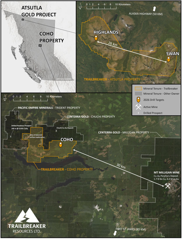
May 25, 2026 – Trailbreaker Resources Ltd. (TBK.V) (“Trailbreaker” or “the Company”) is pleased to provide an update on its activities as it enters the 2026 exploration season. The Company’s primary objective is to undertake inaugural drilling on two distinct targets at its 300 km² Atsutla Gold project in northwestern British Columbia (BC). These include the Highlands high-grade gold vein target and the Swan copper-gold-silver (Cu-Au-Ag) porphyry target.
Following completion of drilling at Atsutla, the Company plans to commence drilling at its Coho Cu-Au porphyry target in central BC (see Figure 1 for location map). All three targets have not been previously drilled and have benefited from extensive geological work, advancing them to drill-ready status.
Daithi Mac Gearailt, CEO of Trailbreaker, commented, “2026 is shaping up to be a landmark year for Trailbreaker. After careful planning, we are excited to commence inaugural drilling on two priority targets at our flagship Atsutla Gold project. These targets are effectively projects in their own right. The Highlands zone is a high-grade gold target with kilometric-scale mineralization, while the Swan zone represents a largely untested Cu-Au-Ag porphyry system with significant discovery potential.
Later in the summer, we plan to advance to drilling at our road-accessible Coho Cu-Au porphyry target, located 30 kilometres west of the Mt. Milligan mine. Each of these three targets has the potential to be a major catalyst for the Company.
With the recent completion of our $3.5 million flow-through financing—upsized due to strong demand—we are well-funded and fully permitted across our key assets. We have also strengthened our technical team with the addition of Charlie Greig as Technical Advisor, who brings a proven discovery track record, including his involvement in the Saddle North deposit of northern BC, ultimately acquired by Newmont.
We anticipate consistent news flow as we enter an active phase of drilling and continued surface exploration across our highly prospective project portfolio.”
Figure 1: Locations of the three targets scheduled for drilling in 2026.
Atsutla Gold Project (link to presentation)
Trailbreaker’s 100%-owned Atsutla Gold project is located 70 km south of the Yukon-British Columbia border and 120 km northwest of the Village of Dease Lake, BC. The project covers over 30,000 hectares of ground with very limited historic exploration. Trailbreaker is planning the inaugural drill program to target two distinct styles of mineralization, separated by a distance of 26 km.
The first target is the high-grade gold showings at the Highlands zone. The Highlands zone covers a 2.0 km by 1.5 km area in the western Atsutla Gold project region, with quartz veins containing coarse visible gold assaying up to 630 g/t Au and 1,894 g/t Ag. Mineralization at the Highlands zone is related to a much larger system (Atsutla West), which includes the Christmas Creek and Snook zones. Combined, this area covers 5.0 km x 4.3 km, located within the Jurassic-aged Christmas Creek batholith. Trailbreaker’s team interprets the gold mineralization to be orogenic in nature, with multiple gold ± silver ± copper-bearing shear zones related to larger faults occurring in the area. No drilling has ever been conducted in the Atsutla West area.
The Swan zone, located 26 km east of the Highlands zone, is a Cu-Au-Ag porphyry target in the younger, Cretaceous-aged Glundebery batholith. Trailbreaker has performed significant geochemical and geophysical surveys to define the drill targets, which occur within a 1.5 km x 1.5 km multi-element (Au-Cu-Ag-arsenic [As]-molybdenum [Mo]-antimony [Sb]-bismuth [Bi]) soil geochemical anomaly. Rock grab samples from the zone grade up to 11.7 g/t Au, 212 g/t Ag, and 0.81% Cu. The geochemical anomaly is coincident with a 2.1 km x 1.4 km donut-shaped chargeability high (defined by a 2024 induced polarization survey) as well as a zone of elevated potassium marked by a magnetic low signature indicated from a 2024 airborne magnetic and radiometric survey. While limited historic drilling has been conducted in the valley adjacent to the Swan zone, the Swan zone itself has never been drilled.
Both zones are fully permitted for the planned work. A diamond drill program of 1,500 to 2,500 m is expected to commence in late June, 2026. Empire Drilling of Smithers, BC has been contracted to perform the drilling.
Trailbreaker is currently planning the inaugural drill program at its 8,000-hectare Coho property, located 90 km north of the Town of Fort St. James, BC and 30 km west of the Mt. Milligan Cu-Au porphyry deposit. The priority target is the Coho zone, a Cu-Au porphyry target with recently completed property-wide geochemical and geophysical surveys. The zone hosts a recently identified coincident chargeability and resistivity anomaly, associated with high-grade gold and copper values from surface rock grab samples. While there has been limited historical drilling within the Coho property, the actual Coho zone has never been drilled.
A diamond drill program of 1,500 to 2,500 m will commence on the Coho zone in September, 2026. All necessary permits have been acquired (see January 19, 2026 news release) and Dorado Drilling of Smithers, BC has been contracted to perform the drilling.
Trailbreaker is also planning to conduct a surface exploration program in the western area of the Coho property. This program will follow up on results released by Pacific Empire Minerals in December, 2025 on the Trident property, which is contiguous with Coho’s western border. Drilling at the Trident property returned results including 183.0 m of 0.77% Cu, 0.51 g/t Au, and 3.4 g/t Ag. The proposed surface exploration program will consist of prospecting, geological mapping, and a grid soil geochemical survey. The team will also ground-truth drill hole locations at the Coho zone in preparation for the upcoming drill program.
About Trailbreaker Resources Trailbreaker Resources is a mining exploration company focused primarily on mining-friendly British Columbia and Yukon Territory, Canada. Trailbreaker is committed to continuous exploration and research, allowing maintenance of a portfolio of quality mineral properties which in turn provides value for shareholders. The company has an experienced management team with a proven track record as explorers and developers throughout the Yukon Territory, British Columbia, Alaska and Nevada.
ON BEHALF OF THE BOARD
Daithi Mac Gearailt
President and Chief Executive Officer
Carl Schulze, P. Geo., Consulting Geologist with Aurora Geosciences Ltd, is a qualified person as defined by National Instrument 43-101 for Trailbreaker’s BC and Yukon exploration projects, and has reviewed and approved the technical information in this release.
Other For new information about the Company’s projects, please visit Trailbreaker’s website at TrailbreakerResources.com and sign up to receive news. For further information, follow Trailbreaker’s tweets at Twitter.com/TrailbreakerLtd, use the ‘Contact’ section of our website, or contact us at (604) 681-1820 or at info@trailbreakerresources.com.
Neither the TSX Venture Exchange nor its Regulation Services Provider (as that term is defined in the policies of the TSX Venture Exchange) accepts responsibility for the adequacy or accuracy of this release.
Forward-Looking Statements Statements contained in this news release that are not historical facts are “forward-looking information” or “forward-looking statements” (collectively, “Forward-Looking Information”) within the meaning of applicable Canadian securities legislation and the United States Private Securities Litigation Reform Act of 1995. Forward-Looking Information includes, but is not limited to, disclosure regarding possible events, conditions or financial performance that is based on assumptions about future economic conditions and courses of action; expectations regarding future exploration and drilling programs and receipt of related permitting. In certain cases, Forward-Looking Information can be identified by the use of words and phrases such as “anticipates”, “expects”, “understanding”, “has agreed to” or variations of such words and phrases or statements that certain actions, events or results “would”, “occur” or “be achieved”. Although Trailbreaker has attempted to identify important factors that could affect Trailbreaker and may cause actual actions, events or results to differ materially from those described in Forward-Looking Information, there may be other factors that cause actions, events or results not to be as anticipated, estimated or intended. In making the forward-looking statements in this news release, if any, Trailbreaker has applied several material assumptions, including the assumption that general business and economic conditions will not change in a materially adverse manner. There can be no assurance that Forward-Looking Information will prove to be accurate, as actual results and future events could differ materially from those anticipated in such statements. Accordingly, readers should not place undue reliance on Forward-Looking Information. Except as required by law, Trailbreaker does not assume any obligation to release publicly any revisions to Forward-Looking Information contained in this news release to reflect events or circumstances after the date hereof or to reflect the occurrence of unanticipated events.
April 27, 2026 – Trailbreaker Resources Ltd. (TBK.V) (“Trailbreaker” or “the Company”) is pleased to announce the appointment of Mr. Charlie Greig, MSc, P. Geo, as a Technical Advisor to the Company.
Mr. Greig is a British Columbia (BC)-based professional geologist with an extensive career and successful track record in mineral exploration. He has been involved in numerous projects ranging from grassroots-stage to production-stage development.
Charlie’s involvement in projects put into production include: La India in Mexico (Grayd–Agnico Eagle), Wolverine in Yukon (Atna-Westmin, Yukon Zinc), Alamo Dorado in Mexico (Corner Bay-Pan American Silver), Brucejack Lake (Pretium), and Bisha in Eritrea (Nevsun). His involvement in advanced-stage projects includes: Ike (Amarc Resources), Red Mountain (Lac Minerals, Seabridge, Ascot Resources), Casino (Western Copper and Gold), and Silbak Premier-Big Missouri (Westmin, Ascot Resources).
Mr. Greig served as Vice President of Exploration for GT Gold Corp. and was instrumental in leading the team to discover the Saddle North copper-gold (Cu-Au) porphyry deposit and the high-grade gold-silver mineralized zone at Saddle South. GT Gold was acquired by Newmont Corporation in 2021 for C$456 million.
Most recently, Charlie has been the lead technical advisor for American Eagle Gold’s NAK project, a Cu-Au porphyry project near Smithers, BC, in partnership with Teck Resources and South32 Ltd. He has also acted as a technical advisor for Kingfisher Metals, Happy Creek Minerals, and Hercules Metals. He is currently Executive Chairman at Evergold Corp. and CEO of Metal Energy Corp.
Daithi Mac Gearailt, CEO of Trailbreaker, commented, “We are delighted to welcome Charlie to the Trailbreaker team. His experience working in BC Cu-Au porphyry deposits will be instrumental in guiding exploration at our Coho, Atsutla, and Liberty projects.”
As compensation for his role as Technical Advisor, Trailbreaker has issued Charlie Greig 100,000 stock options with a strike price of C$0.40 per share for a period of five years (see April 16, 2026 news release).
About Trailbreaker Resources
Trailbreaker Resources is a mining exploration company focused primarily on mining-friendly British Columbia and Yukon Territory, Canada. Trailbreaker is committed to continuous exploration and research, allowing maintenance of a portfolio of quality mineral properties which in turn provides value for shareholders. The company has an experienced management team with a proven track record as explorers and developers throughout the Yukon Territory, British Columbia, Alaska and Nevada.
ON BEHALF OF THE BOARD
Daithi Mac Gearailt
President and Chief Executive Officer
Carl Schulze, P. Geo., Consulting Geologist with Aurora Geosciences Ltd, is a qualified person as defined by National Instrument 43-101 for Trailbreaker’s BC and Yukon exploration projects, and has reviewed and approved the technical information in this release.
Other
For new information about the Company’s projects, please visit Trailbreaker’s website at TrailbreakerResources.com and sign up to receive news. For further information, follow Trailbreaker’s tweets at Twitter.com/TrailbreakerLtd, use the ‘Contact’ section of our website, or contact us at (604) 681-1820 or at info@trailbreakerresources.com.
Neither the TSX Venture Exchange nor its Regulation Services Provider (as that term is defined in the policies of the TSX Venture Exchange) accepts responsibility for the adequacy or accuracy of this release.
Forward-Looking Statements
Statements contained in this news release that are not historical facts are “forward-looking information” or “forward-looking statements” (collectively, “Forward-Looking Information”) within the meaning of applicable Canadian securities legislation and the United States Private Securities Litigation Reform Act of 1995. Forward-Looking Information includes, but is not limited to, disclosure regarding possible events, conditions or financial performance that is based on assumptions about future economic conditions and courses of action; expectations regarding future exploration and drilling programs and receipt of related permitting. In certain cases, Forward-Looking Information can be identified by the use of words and phrases such as “anticipates”, “expects”, “understanding”, “has agreed to” or variations of such words and phrases or statements that certain actions, events or results “would”, “occur” or “be achieved”. Although Trailbreaker has attempted to identify important factors that could affect Trailbreaker and may cause actual actions, events or results to differ materially from those described in Forward-Looking Information, there may be other factors that cause actions, events or results not to be as anticipated, estimated or intended. In making the forward-looking statements in this news release, if any, Trailbreaker has applied several material assumptions, including the assumption that general business and economic conditions will not change in a materially adverse manner. There can be no assurance that Forward-Looking Information will prove to be accurate, as actual results and future events could differ materially from those anticipated in such statements. Accordingly, readers should not place undue reliance on Forward-Looking Information. Except as required by law, Trailbreaker does not assume any obligation to release publicly any revisions to Forward-Looking Information contained in this news release to reflect events or circumstances after the date hereof or to reflect the occurrence of unanticipated events.
This news release is being filed pursuant to Coordinated Blanket Order 51-933 Exemptions to Permit Semi-Annual Reporting for Certain Venture Issuers.
April 24, 2026 – Trailbreaker Resources Ltd. (TBK.V) (“Trailbreaker” or “the Company) announces that it is adopting semi-annual financial reporting in place of quarterly reporting, effective for the three-month interim period ending (Q1 2026 period end date).
The British Columbia Securities Commission recently issued Coordinated Blanket Order 51-933, which allows eligible venture issuers listed on the TSX Venture Exchange or Canadian Securities Exchange to file financial reports twice a year rather than four times. Trailbreaker meets the conditions of the Order and will begin relying on it starting with its Q1 2026 interim period.
As a result, the Company will not be filing an interim financial report or related MD&A for the three-month period ending March 31, 2026, nor for its nine-month period ending September 30, 2026. Trailbreaker will continue to file audited annual financial statements and semi-annual interim reports as required.
“For a company at our stage, preparing quarterly financial reports is a significant administrative burden relative to the information value they provide to our shareholders,” said Daithi Mac Gearailt, President and CEO of Trailbreaker Resources Ltd. “Shifting to semi-annual reporting lets us direct more of our resources toward exploration and creating value in the ground, while still meeting our disclosure obligations to investors.”
Daithi Mac Gearailt
President and Chief Executive Officer
Neither the TSX Venture Exchange nor its Regulation Services Provider (as that term is defined in the policies of the TSX Venture Exchange) accepts responsibility for the adequacy or accuracy of this release.
April 16, 2026 – Trailbreaker Resources Ltd. (TBK.V) (“Trailbreaker” or “the Company) announces that it has granted an aggregate of 4,050,000 stock options (the “Options”) pursuant to its stock option plan.
A total of 3,100,000 Options has been granted to officers and directors of the Company, exercisable at a price of $0.40 per common share for a period of ten (10) years from the date of grant.
In addition, the Company has granted 950,000 Options to consultants and advisors, exercisable at a price of $0.40 per common share for a period of five (5) years from the date of grant.
All Options are subject to the terms and conditions of the Company’s stock option plan and the policies of the TSX Venture Exchange.
ON BEHALF OF THE BOARD
Daithi Mac Gearailt
President and Chief Executive Officer
Neither the TSX Venture Exchange nor its Regulation Services Provider (as that term is defined in the policies of the TSX Venture Exchange) accepts responsibility for the adequacy or accuracy of this release.