TRAILBREAKER Resources LTD
COHO PROPERTY

Introduction
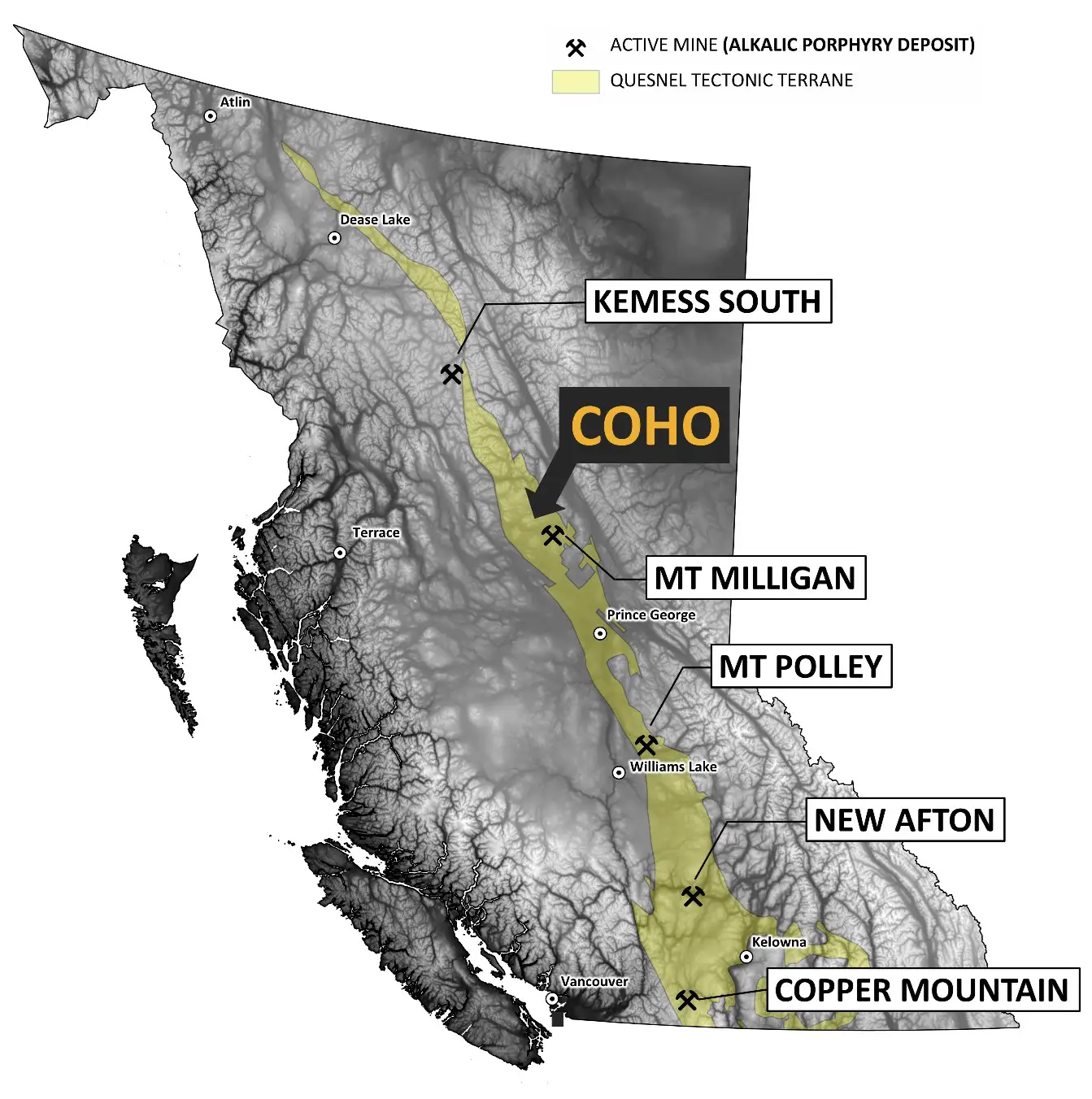
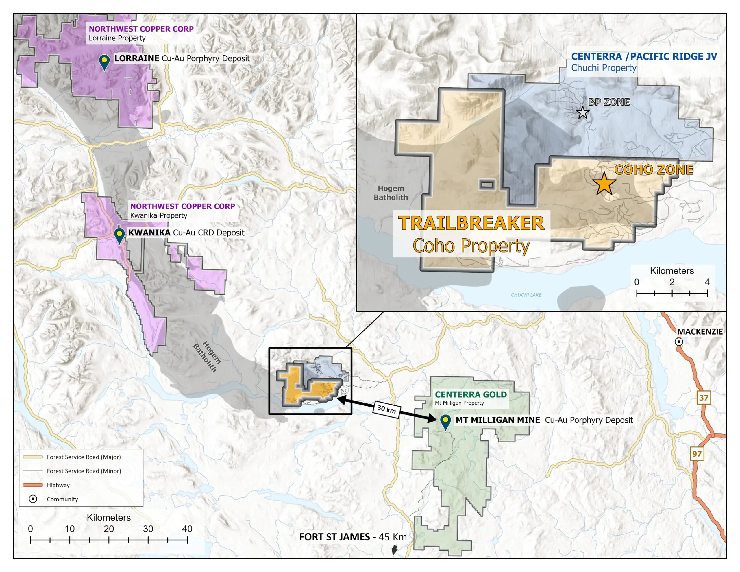
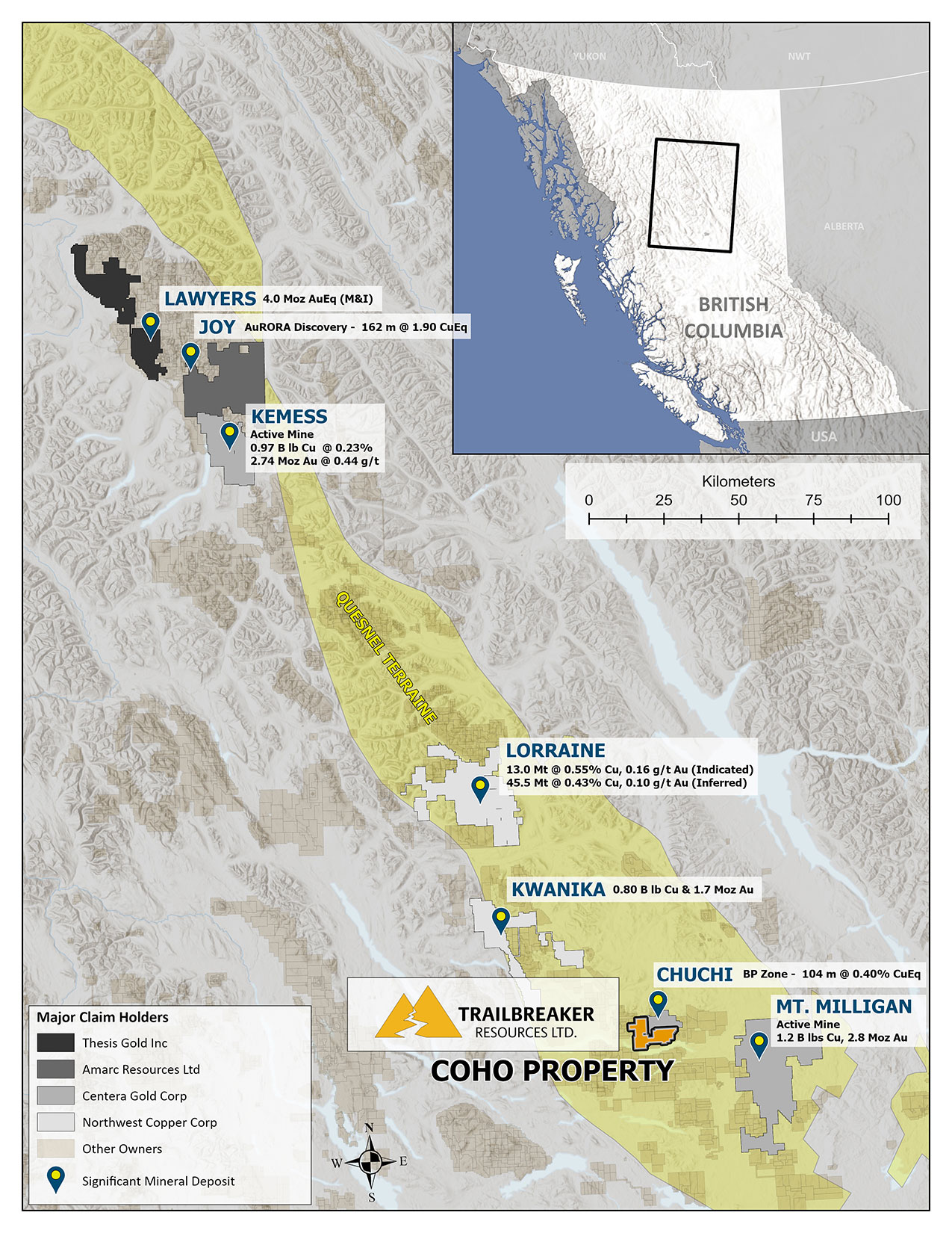
The 8000-hectare Coho property is an early-stage alkalic copper-gold (Cu-Au) porphyry target located in central British Columbia, 90 km north of the town of Fort St. James, BC. It is situated within the prolific Quesnel tectonic terrane which hosts many of BC’s largest Cu-Au porphyry deposits. Centerra Gold’s Mount Milligan Mine (2.8 Moz Au, 1.2 B lb Cu) is located 30 km southwest of the Coho property and shares similar geology and mineralization. The property is under option for 100% ownership and is fully permitted for diamond drilling.
Location & Access
The Coho property is located 90 km north of the town of Fort St. James, BC and 185 km northwest of Prince George, BC. There is excellent road access via Forest Service Roads throughout the claims.
History
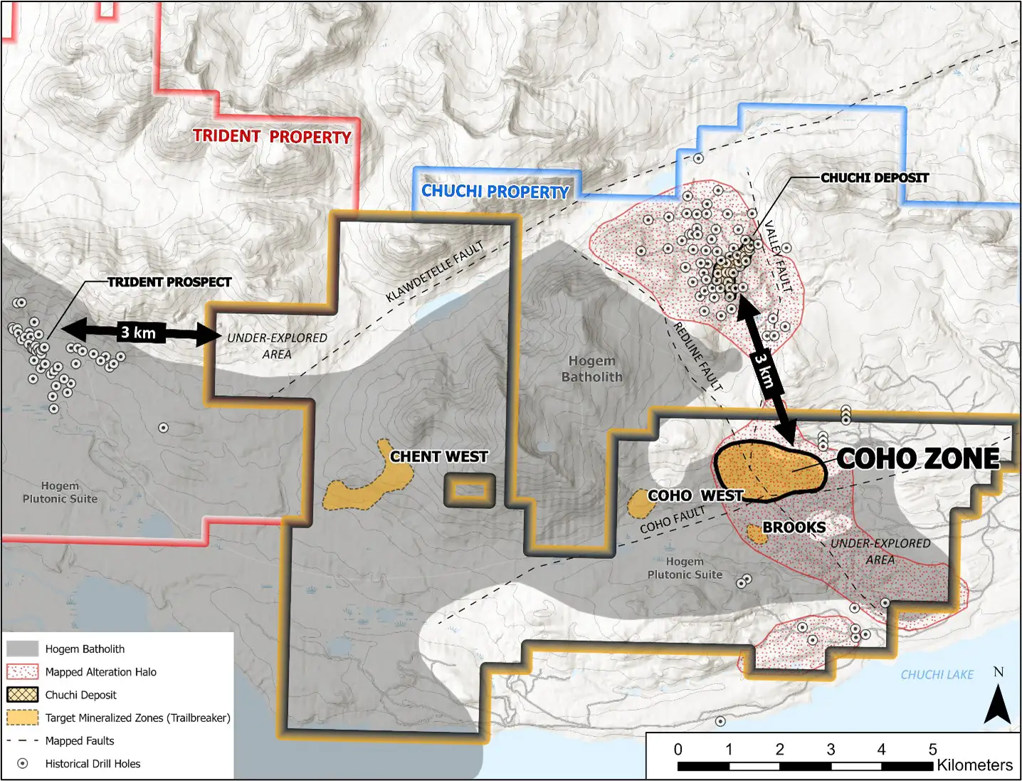
Exploration at the Coho property dates back to the 1960s and includes property-wide soil geochemical surveys, geophysical surveys, and 2,186 meters of diamond drilling in 20 widely spaced holes. Several kilometer-scale geochemical anomalies have been defined, and narrow, high-grade copper-gold values were intersected in historic diamond drill holes. Recent exploration efforts have outlined several new copper-gold porphyry targets that remain to be drill tested. These include the Chent West, Coho West, Brooks, and Coho zones.
Trailbreaker’s Coho property is contiguous with the Chuchi Project which is currently being advanced by a joint venture between Centerra Gold and Pacific Ridge Exploration. The Chuchi Project has undergone a considerable amount of exploration since its discovery in the 1960s, by companies such as Noranda, BP, and AuRico, with over 11,000 meters of diamond drilling in 53 drill holes. The majority of this drilling has been focused on the BP zone which represents a 1.5 km x 1.5 km area of copper-gold mineralization with a historic, non-NI 43-101 compliant resource of 50 million tonnes grading between 0.21 – 0.40% Cu and 0.21 – 0.44 g/t Au. Significant drill intersections include: 16 m of 1.55% CuEq within 100 meters of 0.51% CuEq (1991 drill campaign), and 382 meters of 0.27% CuEq (2024 drill campaign). The BP zone sits on the north-south Valley/Redline fault structure that trends south into Trailbreaker’s Coho property.
Geology / Mineralization
Trailbreaker’s Coho property covers similar geology and mineralization to the BP zone (3 km to the north) and the Mount Milligan Cu-Au porphyry deposit (30 km to the southeast). Situated within the prolific Quesnel tectonic terrane, the Coho property is underlain by Lower Jurassic volcanic and sedimentary rocks of the Takla Group intruded by Jurassic monzodiorite and syenite porphyry intrusions associated with the margin of the Hogem batholith.
The Coho property is an alkalic Cu-Au porphyry target. This type of mineralized system commonly forms in clusters and have strong potential for significant gold content. Examples of such deposits along the Quesnel terrane include: Mount Milligan, Mount Polley (measured and indicated resource of 1.25 B lbs Cu, 1.9 Moz Au), Kemess (measured and indicated resource of 1.7 B lbs Cu, 4.4 Moz Au), Red Chris (reserves of 8.1 Moz Au, 4.8 B lbs Cu), and Amarc’s new AuRORA discovery in the JOY district (recent drill results include 0.98 g/t Au, 0.25% Cu over 271 m).
Coho Zone
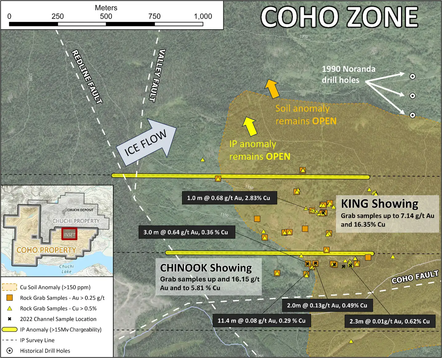
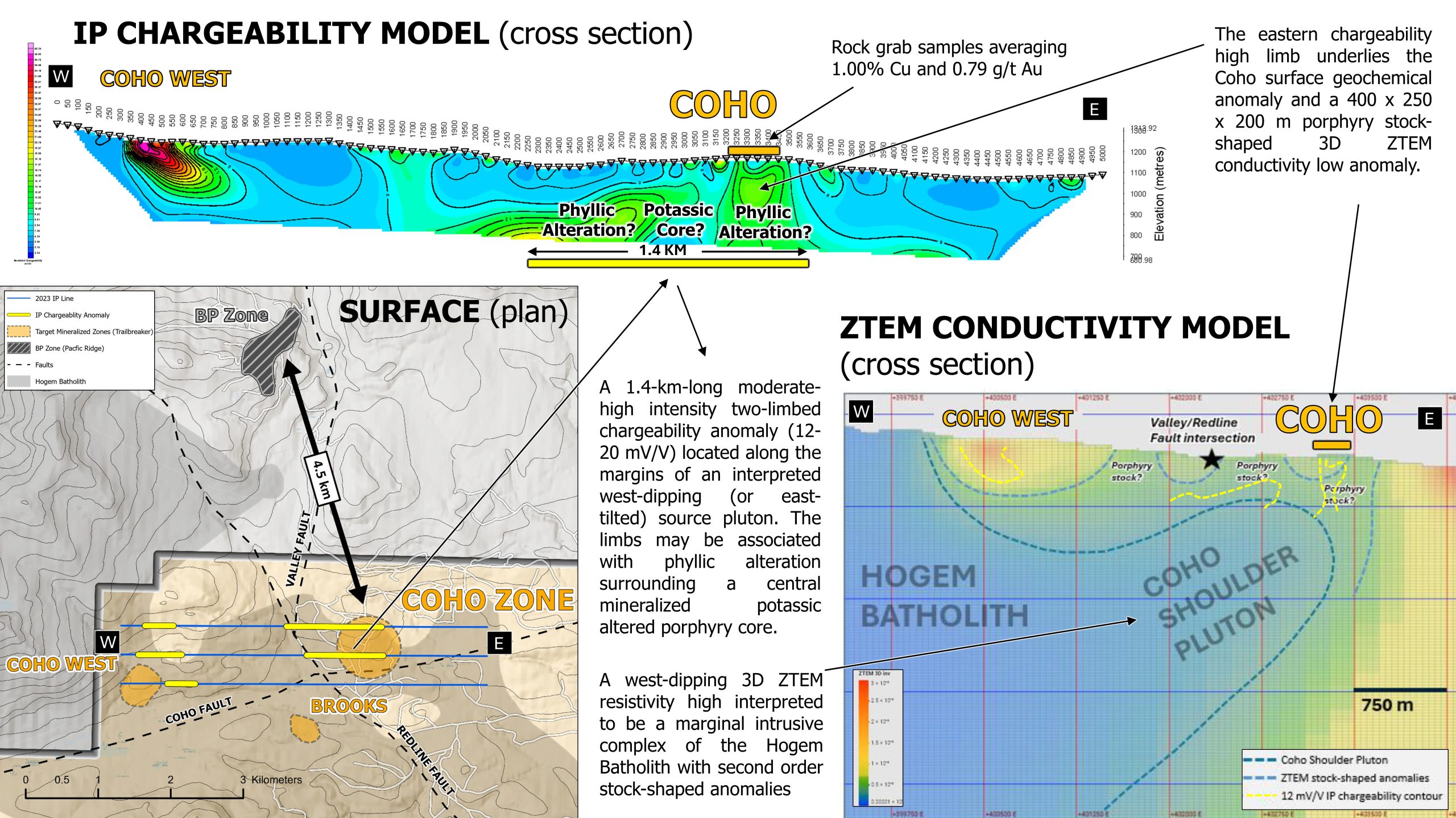
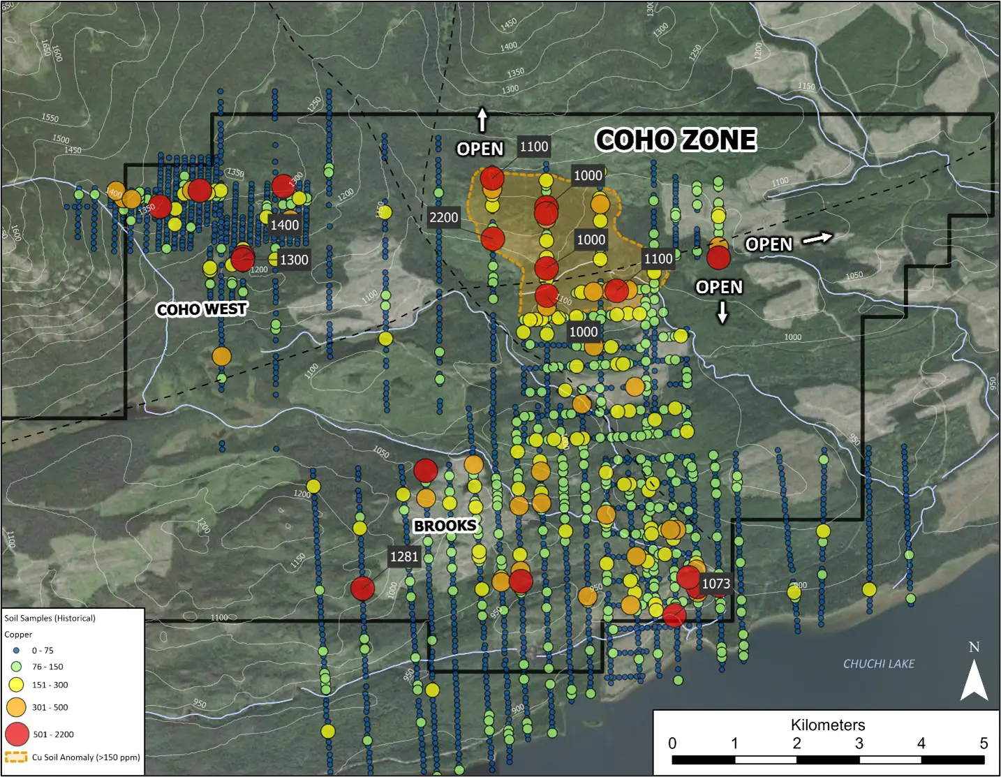
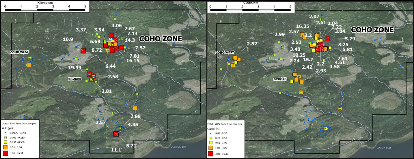
The Coho zone is the priority target and is defined by a 650 x 550 m Cu-Au-Ag surface geochemical anomaly that is hosted in diorite and spatially associated with an ENE-trending fault zone (Coho fault) and gabbro dykes. Two additional faults, the Valley and Redline, extend south from the BP zone (Chuchi Project) and converge with the Coho fault at the Coho zone.
A total of 135 rock grab samples taken at the Coho zone from 2020 to 2022 returned the following values:
- Up to 16.15 g/t Au, with an average of 0.79 g/t Ag (median 0.04 g/t)
- Up to 16.35% Cu, with an average of 1.00% Cu (median 0.31%)
- Up to 67.3 g/t Ag, with an average of 7.7 g/t Ag (median 2.2 g/t)
Although these are grab samples, and selective by nature, the grades are considerably higher than historic drill and trench intersections at the BP zone.
A recent (2022/2023) airborne ZTEM and ground-based IP survey identified a 400 m x 250 m x 200 m deep interpreted porphyry intrusive complex (3D ZTEM anomaly) with a two-limbed IP chargeability high anomaly that spans more than 1.4 km. The chargeability limbs may be associated with phyllic alteration surrounding a central mineralized potassic-altered porphyry core. The eastern limb underlies both the surface geochemical anomaly and 3D ZTEM intrusive complex identified at the Coho zone and is believed to represent an eastward tilted porphyry copper-gold system similar to the nearby Mount Milligan deposit.
Surface Exploration Highlights
Coho Zone – Geophysical Target
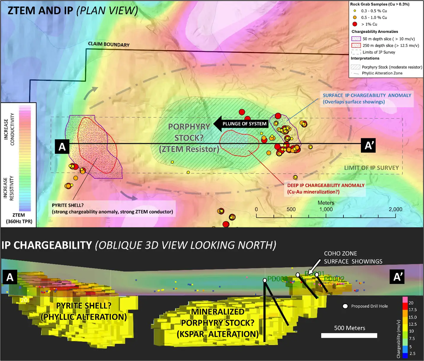
The Coho zone is located 4.5 km south of the BP deposit and believed to be situated along the same Valley/Redline fault structure that hosts the BP deposit. Alkalic porphyry deposits commonly occur in clusters and Trailbreaker’s team believes the Coho property, in particular the Coho zone, may represent a similar but higher-grade Cu-Au porphyry deposit to the BP deposit, and that this system is part of a cluster of deposits found along the margin of the Hogem batholith. The high grades of gold found in the surface sampling at the Coho zone also present the potential of a well-endowed porphyry gold system, similar to the high gold grades found at Mount Milligan (average mine grade of 0.39 g/t Au). The Coho zone has never been drilled and remains the top priority drill target.
Maps
-

- Soil Geochemistry (Cu)
-
- Rock Grab Geochemistry
Images
-
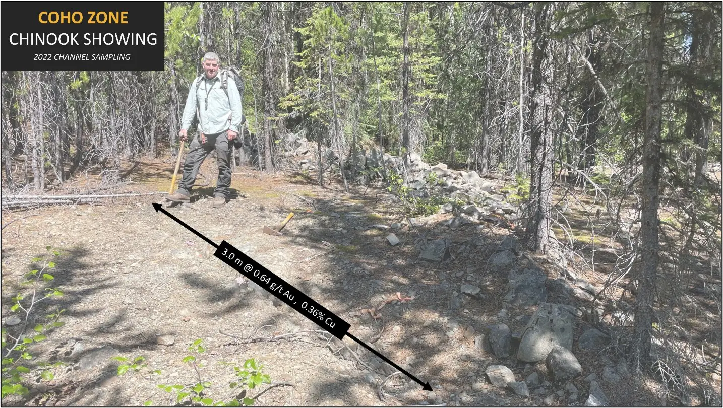
- Coho Zone – Chinook Showing
-
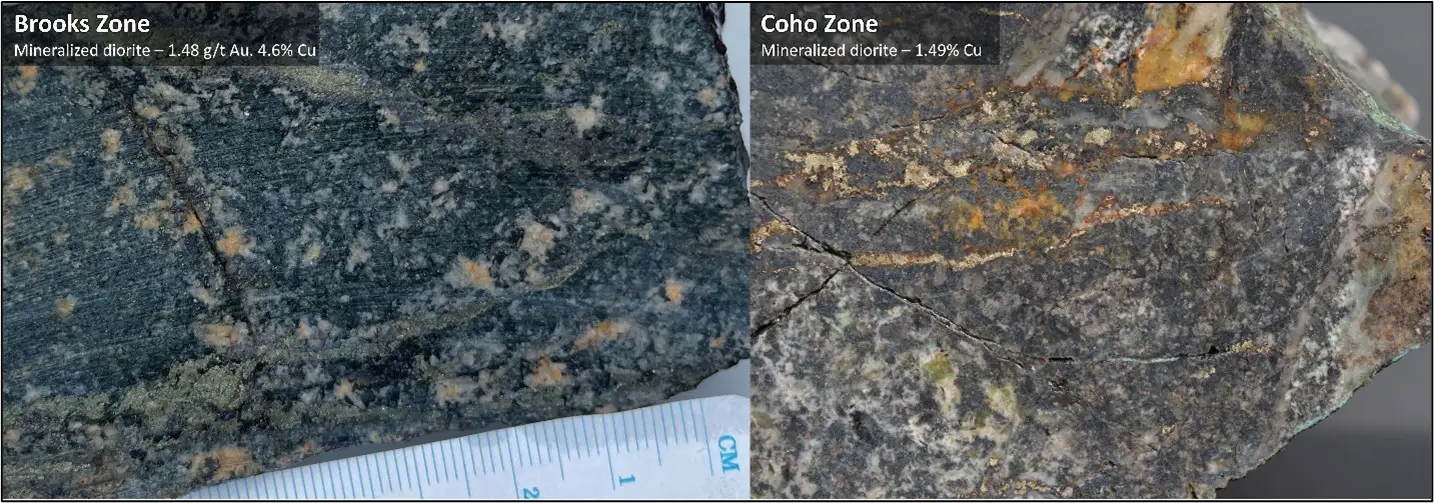
- Coho Property – Cu-Au Mineralization
Presentation
Address
Trailbreaker Resources Ltd.
650 W Georgia St # 2110
Vancouver, British Columbia
Canada, V6B 4N9