March 31, 2026 – Trailbreaker Resources Ltd. (TBK.V) (“Trailbreaker” or “the Company”), announces that, subject to TSX Venture Exchange approval, it intends to extend the term of 2 million common share purchase warrants (the “Warrants”) by one (1) year, to April 10, 2027. The Warrants were issued April 10, 2024 pursuant to a private placement financing, with an exercise price of $0.60 for 2 years. The Warrants’ exercise price will remain unchanged.
ON BEHALF OF THE BOARD
Daithi Mac Gearailt
President and Chief Executive Officer
Neither the TSX Venture Exchange nor its Regulation Services Provider (as that term is defined in the policies of the TSX Venture Exchange) accepts responsibility for the adequacy or accuracy of this release.
March 25, 2026 – Trailbreaker Resources Ltd. (TBK.V) (“Trailbreaker” or “the Company”), further to its news releases dated February 26, 2026, March 3, 2026, and March 11, 2026, is pleased to announce that it has closed its non-brokered charity flow-through private placement (the “Offering”) for gross proceeds of $3.5 million. The Company has issued:
2,500,000 CMETC flow-through units (“CMETC FT Units”) at a price of $0.56 per CMETC FT Unit, for aggregate gross proceeds of $1.4 million, to fund critical mineral exploration expenses, each CMETC FT Unit consisting of 1 CMETC FT common share and ½ of a common share purchase warrant, each of which will qualify as a “flow-through share” within the meaning of subsection 66(15) of the Income Tax Act (Canada) (the “Tax Act“). Each full warrant is exercisable at $0.50 for 24 months from the date of issue for one non-flow-through common share; and
4,200,000 flow-through units (“FT Units”) at a price of $0.50 per FT Unit for aggregate gross proceeds of $2.1 million, each FT Unit consisting of 1 FT common share and ½ of a common share purchase warrant, each of which will qualify as a “flow-through share” within the meaning of subsection 66(15) of the Tax Act. Each full warrant is exercisable at $0.50 for 24 months from the date of issue for one non-flow-through common share.
All of the FT Units and CMETC FT Units issued pursuant to the Offering are subject to a hold period in Canada of four months plus one day from closing.
The Company has paid cash finders’ fees totaling $108,150 and issued 324,000 non-transferable broker warrants exercisable at $0.50 for 2 years, in accordance with Exchange policies.
The Company will use an amount equal to the gross proceeds received by the Company from the sale of the FT Units and the CMETC FT Units, pursuant to the provisions in the Tax Act, to incur eligible “Canadian exploration expenses” that qualify, in the case of the FT Units, as “flow-through mining expenditures” within the meaning of the Tax Act, and, in the case of the CMETC FT Units, as “flow-through critical mineral mining expenditures” within the meaning of the Tax Act, and, in each case, for FT Units and CMETC FT Units purchased by eligible British Columbia purchasers, as “BC flow-through mining expenditures” that meet the criteria set forth in subsection 4.721(1) of the Income Tax Act (British Columbia), in respect of the exploration activities on the Company’s properties in British Columbia (the “Qualifying Expenditures”). The Qualifying Expenditures will be incurred on or before December 31, 2027, and renounced by the Company to the initial purchasers of the FT Units and CMETC FT Units effective December 31, 2026.
The proceeds of the Private Placement will be used to advance the Company’s various exploration projects.
The Offering is subject to final Exchange approval.
ON BEHALF OF THE BOARD
Daithi Mac Gearailt
President and Chief Executive Officer
Neither the TSX Venture Exchange nor its Regulation Services Provider (as that term is defined in the policies of the TSX Venture Exchange) accepts responsibility for the adequacy or accuracy of this release.
March 10, 2026 – Trailbreaker Resources Ltd. (TBK.V) (“Trailbreaker” or “the Company”) further to its February 26, 2026 and March 3, 2026 news releases the Company is pleased to announce that it has filed documents with the TSX Venture Exchange (the “Exchange”) seeking Conditional Approval of its non-brokered charity flow-through private placement offering for proceeds of up to $3.5 million (the “Offering”). On receipt of Exchange approval the Company will issue:
up to 2,500,000 CMETC flow-through units at a price of $0.56 per unit , to raise proceeds of up to $1.4 million, to fund Critical Mineral Exploration Expenses (“CMETC FT Units”), each CMETC FT Unit consisting of 1 CMETC FT common share and ½ of a common share purchase warrant, each full warrant being exercisable at $0.50 for 24 months from the date of issue, such CMETC FT Units qualifying for the 30% Critical Mineral Exploration Tax Credit as provided for in the Canadian federal budget of April 7, 2022; and
up to 4,200,000 additional flow-through units at $0.50 per unit to raise proceeds of up to $2.1 million, (“FT Units”) , each FT Unit consisting of 1 FT common share and ½ of a common share purchase warrant, each full warrant being exercisable at $0.50 for 24 months from the date of issue, to fund “flow-through mining expenditures” within the meaning of section 127(9) of the Income Tax Act (Canada) that qualify for the 15% Mineral Exploration Tax Credit.
All of the FT Units and CMETC FT Units issued pursuant to the Offering will be subject to a hold period in Canada of four months plus one day from closing.
Finders fees in cash and warrants may be paid in accordance with Exchange policies.
The Company will use an amount equal to the gross proceeds received by the Company from the sale of the FT Units and the CMETC FT Units, pursuant to the provisions in the Income Tax Act (Canada), to incur eligible “Canadian exploration expenses” that qualify as “flow-through mining expenditures” as both terms are defined in the Income Tax Act (Canada) (the “Qualifying Expenditures”) on or before December 31, 2027, and to renounce all the Qualifying Expenditures in favour of the subscribers of the FT Units effective December 31, 2026.
The proceeds of the Private Placement will be used to advance the Company’s various exploration projects.
ON BEHALF OF THE BOARD
Daithi Mac Gearailt
President and Chief Executive Officer
Neither the TSX Venture Exchange nor its Regulation Services Provider (as that term is defined in the policies of the TSX Venture Exchange) accepts responsibility for the adequacy or accuracy of this release.
March 3, 2026 – Trailbreaker Resources Ltd. (TBK.V) (“Trailbreaker” or “the Company”) further to its February 26, 2026 news release the Company is pleased to announce that its non-brokered $3 million private placement offering (the “Offering”) has been oversubscribed by $500,000 for a total raise of up to $3.5 million. The Offering will now consist of the sale of the following securities:
up to 2,500,000 CMETC flow-through units (“CMETC FT Units”) at a price of $0.56 per CMETC FT Unit, to raise gross proceeds of up to $1.4 million, to fund critical mineral exploration expenses , each CMETC FT Unit consisting of 1 CMETC FT common share and ½ of a common share purchase warrant, each of which will qualify as a “flow-through share” within the meaning of subsection 66(15) of the Income Tax Act (Canada) (the “Tax Act“). Each full warrant is exercisable at $0.50 for 24 months from the date of issue for one non-flow-through common share; and
up to 4,200,000 flow-through units (“FT Units”) at a price of $0.50 per FT Unit to raise gross proceeds of up to $2.1 million, each FT Unit consisting of 1 FT common share and ½ of a common share purchase warrant, each of which will qualify as a “flow-through share” within the meaning of subsection 66(15) of the Tax Act. Each full warrant is exercisable at $0.50 for 24 months from the date of issue for one non-flow-through common share.
All of the FT Units and CMETC FT Units issued pursuant to the Offering, which is subject to TSX Venture Exchange acceptance, will be subject to a hold period in Canada of four months plus one day from closing.
The Company will use an amount equal to the gross proceeds received by the Company from the sale of the FT Units and the CMETC FT Units, pursuant to the provisions in the Tax Act, to incur eligible “Canadian exploration expenses” that qualify, in the case of the FT Units, as “flow-through mining expenditures” within the meaning of the Tax Act, and, in the case of the CMETC FT Units, as “flow-through critical mineral mining expenditures” within the meaning of the Tax Act, and, in each case, for FT Units and CMETC FT Units purchased by eligible British Columbia purchasers, as “BC flow-through mining expenditures” that meet the criteria set forth in subsection 4.721(1) of the Income Tax Act (British Columbia), in respect of the exploration activities on the Company’s properties in British Columbia (the “Qualifying Expenditures”). The Qualifying Expenditures will be incurred on or before December 31, 2027, and renounced by the Company to the initial purchasers of the FT Units and CMETC FT Units effective December 31, 2026.
The proceeds of the Private Placement will be used to advance the Company’s various exploration projects.
ON BEHALF OF THE BOARD
Daithi Mac Gearailt
President and Chief Executive Officer
Neither the TSX Venture Exchange nor its Regulation Services Provider (as that term is defined in the policies of the TSX Venture Exchange) accepts responsibility for the adequacy or accuracy of this release.
February 26, 2026 – Trailbreaker Resources Ltd. (TBK.V) (“Trailbreaker” or “the Company”) today announces a non-brokered structured private placement offering (the “Offering”), to consist of the sale of the following securities:
up to 2,142,857 CMETC flow-through units (“CMETC FT Units”) at a price of $0.56 per CMETC FT Unit, to raise gross proceeds of up to $1.2 million, to fund critical minerals exploration expenses , each CMETC FT Unit consisting of 1 CMETC FT common share and ½ of a common share purchase warrant, each of which will qualify as a “flow-through share” within the meaning of subsection 66(15) of the Income Tax Act (Canada) (the “Tax Act“). Each full warrant is exercisable at $0.50 for 24 months from the date of issue for one non-flow-through common share; and
up to 3,600,000 flow-through units (“FT Units”) at a price of $0.50 per FT Unit to raise gross proceeds of up to $1.8 million, each FT Unit consisting of 1 FT common share and ½ of a common share purchase warrant, each of which will qualify as a “flow-through share” within the meaning of subsection 66(15) of the Tax Act. Each full warrant is exercisable at $0.50 for 24 months from the date of issue for one non-flow-through common share.
All of the FT Units and CMETC FT Units issued pursuant to the Offering, which is subject to TSX Venture Exchange acceptance, will be subject to a hold period in Canada of four months plus one day from closing.
The Company will use an amount equal to the gross proceeds received by the Company from the sale of the FT Units and CMETC FT Units, pursuant to the provisions in the Tax Act, to incur eligible “Canadian exploration expenses” that qualify, in the case of the FT Units, as “flow-through mining expenditures” within the meaning of the Tax Act, and, in the case of the CMETC FT Units, as “flow-through critical mineral mining expenditures” within the meaning of the Tax Act, and, in each case, for FT Units and CMETC FT Units purchased by eligible British Columbia purchasers, as “BC flow-through mining expenditures” that meet the criteria set forth in subsection 4.721(1) of the Income Tax Act (British Columbia), in respect of the exploration activities on the Company’s properties in British Columbia (the “Qualifying Expenditures”). The Qualifying Expenditures will be incurred on or before December 31, 2027, and renounced by the Company to the initial purchasers of the FT Units and CMETC FT Units effective December 31, 2026.
The proceeds of the Private Placement will be used to advance the Company’s various exploration projects.
ON BEHALF OF THE BOARD
Daithi Mac Gearailt
President and Chief Executive Officer
Neither the TSX Venture Exchange nor its Regulation Services Provider (as that term is defined in the policies of the TSX Venture Exchange) accepts responsibility for the adequacy or accuracy of this release.
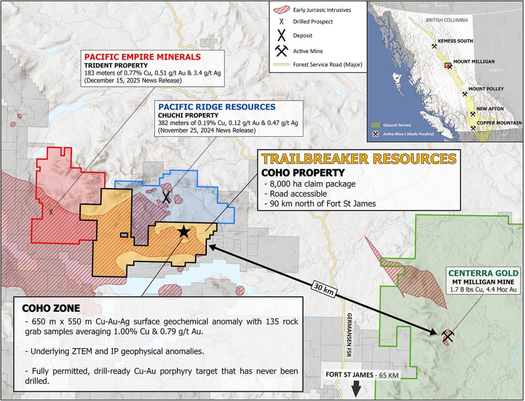
January 19, 2026 – Trailbreaker Resources Ltd. (TBK.V) (“Trailbreaker” or “the Company”) is pleased to announce the receipt of a property-wide exploration permit for its 8,000-hectare Coho property, located in central British Columbia (BC), Canada. The Coho property is a drill-ready copper-gold (Cu-Au) porphyry target situated 30 km west of the Mount Milligan mine.
A 5-year Multi-Year Area-Based (MYAB) Mines Act permit has been approved by the BC Ministry of Mining and Critical Minerals with a provisional expiry date of December 18th, 2030.
Approved Exploration Activities
Diamond drilling, based from up to 50 drill pads
Construction/modification of exploration access trails (up to 15 km)
20 line-km of ground geophysical surveys
Construction of a temporary work camp
Community Engagement
The Coho property is located within the territory of the Takla First Nation, with whom Trailbreaker is committed to continued engagement and to building a working relationship. The Company is currently collaborating with the Takla First Nation on the future drill program.
Daithi Mac Gearailt, CEO of Trailbreaker, commented:“We are thrilled to receive this permit in time for the 2026 exploration season, allowing us to conduct the inaugural drill program at the Coho zone. This is an exciting opportunity to explore an undrilled Cu-Au porphyry target in a prolific mineral district.”
The 8,000-hectare Coho property (Figure 1) is located 90 km north of the Town of Fort St. James, BC. The claims were acquired by Trailbreaker through an option agreement signed in May, 2025 whereby Trailbreaker has the option to acquire a 100% interest (see May 26, 2025 news release). The priority target is the Coho zone, a drill-ready Cu-Au porphyry target with recently completed property-wide geochemical and geophysical surveys. The zone hosts a recently identified chargeability and resistivity anomaly, associated with high-grade gold and copper values from surface rock grab samples. While there has been limited historical drilling on the claims, the Coho zone, has never been drilled.
Located within the Quesnel Tectonic Terrane, the Coho property is situated in a district known for prolific alkalic Cu-Au porphyry deposits and discoveries. The property is located 30 km west of Centerra Gold’s Mount Milligan Cu-Au porphyry deposit, a producing mine with current reserves of 1.2 B lbs Cu and 2.8 Moz Au1. Pacific Empire Minerals’ (‘PEMC’) Trident property is contiguous with the Coho property’s western border. On December 15th, 2025, PEMC reported a drill intercept of 0.77% Cu, 0.51 g/t Au, and 3.4 g/t silver (Ag) over 183.0 m from the ‘A-zone’, located only 3.5 km west of the Coho property2. To the north lies Pacific Ridge Resources’ Chuchi property, where 2024 drilling returned 382.0 m of 0.19% Cu, 0.12 g/t Au, and 0.47 g/t Ag3 from the BP zone.
Figure 1: Trailbreaker’s Coho property is located 30 km northwest of Centerra Gold’s Mt. Milligan Cu-Au porphyry deposit, and 3.5 km east of Pacific Empire Minerals’ Trident property, where recent drill results include 183.0 m of 0.77% Cu, 0.51 g/t Au, and 3.4 g/t Ag.
The Coho zone is defined by a 650 x 550 m Cu-Au-Ag surface rock and soil geochemical anomaly within diorite, and spatially associated with an ENE-trending fault zone (the Coho fault) and gabbro dykes. Two additional faults, the Valley and Redline faults, extend south from the BP zone (Chuchi property) and converge with the Coho fault at the Coho zone. Historic surface grab samples at the Coho zone returned values up to 16.15 g/t Au, 16.35% Cu, and 67.3 g/t Ag.
A recent (2022) airborne ZTEM (Z-axis Tipper electromagnetic) survey, followed by a 2023 ground-based induced polarization (IP) survey, identified an interpreted 400 m x 250 m x 200 m-deep porphyry intrusive complex (3D ZTEM anomaly) with a two-limbed IP chargeability high anomaly that spans more than 1.4 km.
The Coho zone is located 4.5 km south of the BP zone (Chuchi property) and is currently interpreted to be situated along the same Valley/Redline fault structure that hosts the BP zone. Alkalic porphyry deposits commonly occur in clusters and Trailbreaker’s team believes the Coho property, in particular the Coho zone, may represent a Cu-Au porphyry system similar to the surrounding prospects and deposits. Trailbreaker has interpreted this system to be part of a cluster of deposits found along the margin of the Hogem batholith.
Trailbreaker Resources is a mining exploration company focused primarily on mining-friendly British Columbia and Yukon Territory, Canada. Trailbreaker is committed to continuous exploration and research, allowing maintenance of a portfolio of quality mineral properties which in turn provides value for shareholders. The company has an experienced management team with a proven track record as explorers and developers throughout the Yukon Territory, British Columbia, Alaska and Nevada.
ON BEHALF OF THE BOARD
Daithi Mac Gearailt
President and Chief Executive Officer
Carl Schulze, P. Geo., Consulting Geologist with Aurora Geosciences Ltd, is a qualified person as defined by National Instrument 43-101 for Trailbreaker’s BC and Yukon exploration projects, and has reviewed and approved the technical information in this release.
Other
For new information about the Company’s projects, please visit Trailbreaker’s website at TrailbreakerResources.com and sign up to receive news. For further information, follow Trailbreaker’s tweets at Twitter.com/TrailbreakerLtd, use the ‘Contact’ section of our website, or contact us at (604) 681-1820 or at info@trailbreakerresources.com.
Neither the TSX Venture Exchange nor its Regulation Services Provider (as that term is defined in the policies of the TSX Venture Exchange) accepts responsibility for the adequacy or accuracy of this release.
Forward-Looking Statements
Statements contained in this news release that are not historical facts are “forward-looking information” or “forward-looking statements” (collectively, “Forward-Looking Information”) within the meaning of applicable Canadian securities legislation and the United States Private Securities Litigation Reform Act of 1995. Forward-Looking Information includes, but is not limited to, disclosure regarding possible events, conditions or financial performance that is based on assumptions about future economic conditions and courses of action; expectations regarding future exploration and drilling programs and receipt of related permitting. In certain cases, Forward-Looking Information can be identified by the use of words and phrases such as “anticipates”, “expects”, “understanding”, “has agreed to” or variations of such words and phrases or statements that certain actions, events or results “would”, “occur” or “be achieved”. Although Trailbreaker has attempted to identify important factors that could affect Trailbreaker and may cause actual actions, events or results to differ materially from those described in Forward-Looking Information, there may be other factors that cause actions, events or results not to be as anticipated, estimated or intended. In making the forward-looking statements in this news release, if any, Trailbreaker has applied several material assumptions, including the assumption that general business and economic conditions will not change in a materially adverse manner. There can be no assurance that Forward-Looking Information will prove to be accurate, as actual results and future events could differ materially from those anticipated in such statements. Accordingly, readers should not place undue reliance on Forward-Looking Information. Except as required by law, Trailbreaker does not assume any obligation to release publicly any revisions to Forward-Looking Information contained in this news release to reflect events or circumstances after the date hereof or to reflect the occurrence of unanticipated events.